
As part of my ongoing, yearlong foray into fiction set in the ancient Mediterranean, I am now re-reading Mary Renault’s The King Must Die. There is so much history and speculation packed into this book, that I make free to do a series of posts on different topics from it, en route to the final book review. So, buckle up! I hope you like ancient historical fiction! (And, since you are visiting Out of Babel Books, I assume you at least don’t hate it!) Today’s topic is Renault’s theme of the two conflicting cultures of Hellenes vs. what they call the “Shore People.”
On the timing of the Theseus story
I have always had the impression that the story of Theseus was one of the older historical myths. It happens when Knossos, on Crete, is still a thriving city. So, in my mind, I put it a few generations before the Iliad. Madeline Miller, author of Circe, seems to agree. In her book, Circe hears of Theseus having killed the Minotaur well before Odysseus comes to land on her island.
If you do the math, Theseus living before the Odyssey would also put him living before Agamemnon returns from the war at Troy and is slaughtered in his bath by his wife, Clytemnestra. In the play Agamemnon (written, of course, much later), Clytemnestra kills her husband in revenge for his having sacrificed their thirteen-year-old daughter before he sailed for Troy, in addition to a couple of other grudges. Like most women, I find it hard not to think Clytemnestra has a case.
Renault, however, takes a different tack. She has a teenaged Theseus hear the following story from a bard:
The song he gave us was the Lay of Mycenae: how Agamemnon the first High King took the land from the Shore Folk, and married their Queen. But while he was at war she brought back the old religion, and chose another king; and when her lord came home she sacrificed him, though he had not consented. Their son, who had been hidden by the Hellenes, came back when he was a man, to restore the Sky Gods’ worship and avenge the dead. But in his blood was the old religion, to which nothing is holier than a mother. So, when he had done justice, horror sent him mad, and the Night’s Daughters chased him half over the world.
ibid, p. 40 in my copy
So here we have Agamemnon, Clytemnestra, their son Orestes, and the Furies. At the same time, this passage raises some questions.
The Shore People and Their Appearance
The Shore People make their appearance on the very first page of The King Must Die.
Our house is Hellene, sprung from the seed of Ever-Living Zeus. We worship the Sky Gods before Mother Dia and the gods of the earth. And we have never mixed our blood with the blood of the Shore People, who had the land before us.
-ibid, p. 1
As the story progresses, it rapidly becomes obvious that the Hellenes have, in fact, mixed their blood with the blood of the Shore People. There is the story of Agamemnon, above; Theseus is said to be “blonde and blue-eyed like the Hellenes, but small and wiry like the Shore People,” and Theseus, who is very promiscuous, even has a child who “came out small and dark, but so was [his mother’s] brother.”
So we have two populations, one that is native to the Greek coastlands (or at least has been there a long time), and one that came there from the steppes. Theseus’s grandfather explains to him their ethnic history, which he got from his own grandfather:
“Long ago, he said, our people lived in the northland, beyond Olympos. He said, and he was angry when I doubted it, that they never saw the sea. Instead of water they had a sea of grass, which stretched as far as the swallow flies, from the rising to the setting sun. They lived by the increase of their herds, and built no cities; when the grass was eaten, they moved where there was more. … When they journeyed, the barons in their chariots rode round about, guarding the flocks and the women … [Lord Poseidon] told the King Horse, and the King Horse led them. When they needed new pastures, they let him loose; and he, taking care of the people as the god advised him, would smell the air seeking food and water. The barons followed him, to give battle if his passage was disputed; but only the god told him where to go.”
ibid, pp. 16 – 17
This is a description of the Indo-European lifestyle and homeland. The Indo-Europeans took their reverence for the horse, and their wheeled carts and chariots, with them wherever they went, including to Scandinavia. So the Hellenes are Indo-European, and the Shore People, presumably, Hamitic or Semitic.
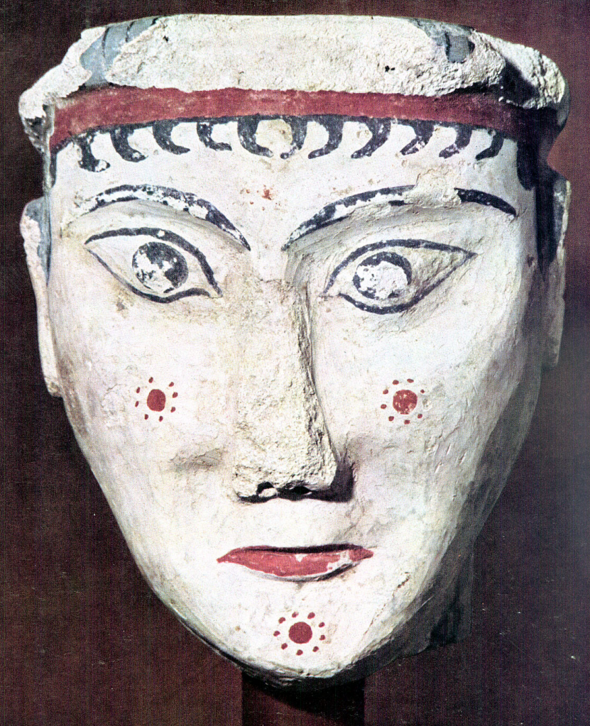
The mask at the top of this post is Mycenaean. Mycenae is located in the Peloponnesian Peninsula, which is also the location of Troizen, Theseus’s home. The ancient Mycenaean culture, older than classical Greece, took its cues from the Cretan urban culture of the time. In later Greece, you get men wearing himations and women wearing finely woven chitons. This is usually how Helen of Troy, for example, is illustrated. However, she probably looked more like the Mycenaean and Cretan women. Here is someone’s attempt to reconstruct the probable hairstyle and costume of the most beautiful woman in the world:
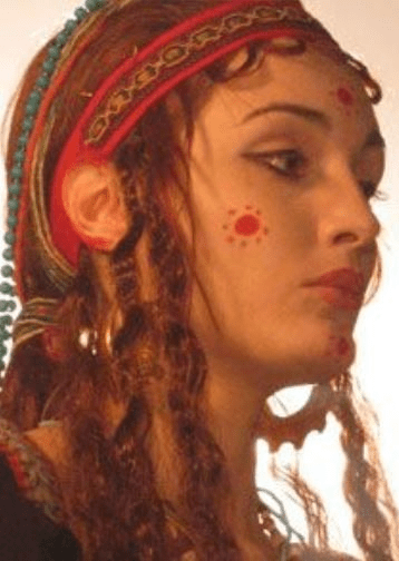
Notice the Egyptian-style, kohl-lined eyes, and the red suns for makeup. Helen might have been blonde, being a Hellene, but her clothing was perhaps more like this.
Here is someone else, reconstructing a traditional Mycenean costume and pose:
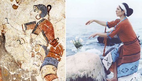
I’m guessing these fashion choices came from the Shore People.
Theseus’s mother is described as wearing this ancient Mycenaean style. She wears a tiered, flounced skirt hung with charms, exposed breasts (what was going on, Crete and Mycenae?) and hair that is curled by the use of “crimping braids” (probably to attain a very curly look for those who do not, like the Shore People, have it naturally). Though a blonde Hellene, she is a priestess of the mother goddess, and so she takes some of her cues from the Shore People, and here is where we find the tension.
The Shore People and Their Religion
Both the Hellenes and the Shore People practice the sacrifice of their kings. However, there is a difference. For the Hellenes, it does not come on a regular schedule. Theseus’s grandfather explains:
“When the work of the King Horse was done, he was given to the god … And in those days, said my great-grandfather, as with the King Horse, so with the King. When the king was dedicated, he knew his moira [i.e. doom]. In three years, or seven, or nine, or whenever the custom was, his term would end and the god would call him. And he went consenting, or else he was no king, and no power would fall on him to lead the people. And the custom changes, Theseus, but the token never. … Later the custom altered. They ceased to offer the King at a set time. They kept him for the extreme sacrifice … And it was no one’s place to say to him, ‘It is time to make the offering.’ He was the nearest to the god, because he had consented to his moira; and he himself received the god’s commandment. And so it is still, Theseus. We know our time. … It is not the sacrifice … it is not the bloodletting that calls down power. It is the consenting, Theseus. The readiness is all.”
ibid. pp. 18 – 19
This might explain why so many kurgan burials are of high-born individuals who seem not to have died of old age.
It also, of course, explains the title of the book.
Meanwhile, it has been established that the Shore People do things a different way: “old laments have come down from the Shore People, of young heroes who love a goddess for a year, and foreknow their deaths” (p. 37). In other words, the Shore People treat their king primarily as the goddess or priestess’s consort, and kill him after just a year.
Marija Gimbutas has tried to make the case that the Shore People practiced a gentle, feminine, goddess-worshipping religion, and that they were cruelly exterminated by the warlike, sky-god worshipping evil Indo-Europeans. Renault is not going to paint with such a broad brush. Realistically, she shows both groups living next to one another and influencing each other. Also, throughout the course of the story, she is going to show by increasingly vivid illustrations that these two cultural systems are absolutely incompatible with each other. And that the mother-worship, in the end, is at least as bloody as the worship of Zeus.
Renault’s take on the story of Agamemnon is a great illustration of this. She interprets the story as a conflict between Clytemnestra’s mother-goddess culture and Agamemnon’s sky-father culture. When Clytemnestra brings back the “old religion,” it means that Agamemnon must die–not in battle, not some day, but now, and actually, yesterday. It means that Orestes is doubly cursed. He has loyalty to both religions, with their incompatible demands, and he is put at the mercy of the furies, the representatives of the goddess-religion. They chase him because he killed his mother, but if we string out the implications, even if he had not, they would probably be chasing him anyway. After all, he is a male heir to the throne, so his days are definitely numbered. Behold, the kindness of the religion of the goddess.
Obviously, there are some universal truths and some redemptive metaphors here, hidden under a thick layer of occultism, war between the sexes, and general pain and suffering for everyone. It is going to take a much greater King than Theseus to cut this difficult knot.
Seasonal Postscript
Oh, and Happy Valentine’s Day to everyone! Such a romantic post, I realize.

