Graham Hancock’s Big Idea

Photo by Ylanite Koppens on Pexels.com

In this post I attempt to summarize Graham Hancock’s book Fingerprints of the Gods: The Evidence of Earth’s Lost Civilization (1995). This book influenced the background for my novels. It also, in my mind, dovetails with Douglas Van Dorn’s biblical/archaeological research on giants in ways that I am sure Hancock never intended or imagined.

This post is only a summary. It will naturally be much less convincing than the book itself. My copy of Fingerprints runs 578 pages counting the bibliography and index. Hancock builds up to his thesis slowly, presenting many different lines of evidence and dropping mysterious hints to keep the reader intrigued. He also has to get into some fairly technical topics, particularly when talking about astronomy. I can’t do any of that in a 1,000-word post. So, like a bucket of cold water in the face, you will be treated to Hancock’s thesis in all its bizarre and fascinating glory.

Incredibly Sophisticated, Incredibly Ancient Maps

Hancock’s first two chapters are dedicated to the details of a number of old maps drawn up during the 1500s which show parts of South America that were undiscovered by Europeans at that time. More intriguingly, they show the coast of Antarctica as it appears under the ice. (This was before modern man’s discovery of Antarctica, and before seismic surveys revealed what lay beneath the ice.) The best-known of these is the Piri Reis map (drawn up in A.D. 1513), but there are others, such as the Orontes Finaeus map, the Mercator map, and the Buache map. All these mapmakers drew on older maps, which they compiled. Piri Reis, for example, had access to the Imperial Library at Constantinople, which is probably where he got the sources for his map.

The other amazing thing about these old maps is they often show locations in South America, for example, at accurate longitude and latitude.

The lesson that Hancock draws from these maps is this. Whatever source maps Piri Reis and others used, must themselves have been drawn up by an advanced seafaring civilization that had explored the world and knew how to project longitude and latitude. Amazingly, these seafarer/mathematicians apparently charted Antarctica at a time when it was not yet completely covered in ice. That makes their civilization, how do you say? Very, very old.

Ancient Astronomer/Engineers Again

Hancock then turns to the sophisticated ancient buildings that have baffled us in previous posts. He dedicates ten chapters to the Incan and pre-Incan civilization: the Nazca Lines, the amazing complex at Lake Titicaca, and the tradition that connects these to a bearded culture-bringer (the Viracocha), who came from over the sea.

Eleven more chapters describe the Central American cultures: their obsession with numbers, with calculating exact dates in the distant past and future, with forestalling the apocalypse (including by human sacrifice). They were also sophisticated astronomers. The pyramid complex at Teotihuacan, for example, appears to have been laid out as a scale model of the solar system.

And then there is ancient Egypt. Seventeen chapters are dedicated to it. There are many things to notice. Here are just a few: ancient Egyptian civilization seems to have appeared suddenly as a high civilization, complete with myths, history, engineering, and an obsession with boats. Overall, its history is one of slow decline and loss of knowledge, rather than slow buildup. (Interestingly, the same point has been made about ancient Sumer.)  

The pyramids at Giza do not match the pyramids that are supposed to have been built immediately before and immediately after them. They are far more durable and sophisticated than these others. If we accept the received chronology, the Egyptians built some relatively crummy pyramids, then a few generations later built some amazingly good ones, then turned around and went back to building relatively low-quality pyramids again. Hancock suggests that instead, the Giza pyramids are much older than commonly thought. They were built with knowledge or technology that was subsequently lost. The comparatively crummy pyramids are attempts to copy the ones at Giza.

Hancock writes, “Robert Bauval’s evidence showed that the three pyramids [at Giza] were an unbelievably precise terrestrial map of the three stars of Orion’s belt, accurately reflecting the angles between each of them and even (by their respective sizes) providing some indication of their individual magnitudes. Moreover, this map extended outwards to the north and south to encompass several other structures on the Giza plateau … the Giza monuments were so arranged as to provide a picture of the skies … as they had looked – and only as they had looked – around the year 10,450 BC.” (page 356)

The Great Pyramid at Giza has a ratio of 2pi between its original height and the circumference of its base. This strengthens the argument that it was meant to represent a star (a circle). The Pyramid of the Sun at Teotihuacan has a ratio of 4pi between height and base circumference. Both of these pyramids had to have an odd angle of slope to accomplish this (52 degrees for Giza; 43.5 degrees for Teotihuacan), so it seems to have been intentional. Pi was supposedly not calculated correctly until it was done by Archimedes in the third century BC, but apparently the ancient Egyptians and the ancient Mexicans were familiar with it.

Where Hancock is going with all this is that people on both sides of the Atlantic got their amazing engineering, mathematical, and astronomical knowledge from an older “source” civilization. He thinks it was the same seafaring civilization that apparently charted Antarctica. This impression is strengthened by the Egyptian obsession with boats and by the Incan legends that say all this knowledge came from over the sea.

Is Hancock Arguing for Aliens?

Not in this book.

He has written several books about ancient mysteries. I have not read them all. He has now started writing fiction, and in the one novel of his that I have read, it becomes apparent that his interest in all this is decidedly New Age in character. The novel features an angelic/earth mother spirit guide, telepathic Neanderthals, the whole nine yards. So, I can’t swear that aliens won’t show up at some point. But that is not the thesis of Fingerprints.  Hancock is arguing that there was a very advanced civilization of people well before 10,000 BC. Whether these people were taught by aliens, spirits, or some other stuff like that, he does not say, thankfully. Because, luckily, this book relies heavily on evidence.

So the ancient cartographers were not aliens, not even according to Hancock. But still we have a problem: Where was this civilization located? You don’t normally get an advanced civilization until you have a critical mass of arable land. In short, a continent. Hancock believes he has solved this problem. He believes there was such a mass of land, but that it has since undergone a cataclysm. And now we come to the really wild part of his thesis.

It’s the End of the World As They Knew It

Mythology about a period of cataclysms in ancient times is universal. Hancock dedicates four chapters to this alone. Flood myths, for example, are very common. But most cultures also record things like earthquakes, fire falling from the sky, the sun not rising for some long period of time, or an endless winter. Hancock discusses myths like this in some detail from the following cultures: Aztec, Sumerian, Greek, Inuit, Chinese, Southeast Asian, Pacific, Indian, Egyptian, Mayan, and Norse. It should not be hard for the reader to track down these myths. Some cultures (the Aztecs and the Hopi, for example) believe that disasters come at regular intervals and that each one ushers in a new age of the world.

Hancock believes that these myths are actually historical records (with all the usual caveats about them becoming garbled, etc.) of a period of geologic upheaval that happened within human history. I’ll put it in his own words:

“This geological theory was formulated by Professor Charles Hapgood and supported by Albert Einstein. What it suggests is a complete slippage of our planet’s thirty-mile-thick lithosphere over its nearly 8000-mile-thick central core, forcing large parts of the western hemisphere southward towards the equator and thence to the Antarctic Circle. This movement is not seen as taking place along a due north-south meridian but on a swivelling course – pivoting, as it were, around the central plains of what is now the United States. The result is that the north-eastern segment of North America (in which the North Pole was formerly located in Hudson’s Bay) was dragged southwards out of the Arctic Circle along with large parts of Siberia [which were dragged into the Arctic Circle].

“In the southern hemisphere, Hapgood’s model shows the landmass that we now call Antarctica, much of which was previously at temperate or even warm latitudes, being shifted in its entirety inside the Antarctic Circle. The overall movement is seen as having been in the region of 30 degrees (approximately 2000 miles) and as having been concentrated, in the main, between the years 14,500 BC and 12,500 BC – but with massive aftershocks on a planetary scale continuing at widely-separated intervals down to about 9500 BC.” (page 471)

So that’s the thesis. Here are the things it explains:

  • Why North America was once covered with glaciers, centered around Hudson Bay, and why they suddenly started melting.
  • Why, during the same period of time, Siberia was apparently not covered in glaciers
  • Why there is evidence that the climate was once much warmer in parts of Siberia. We find flash-frozen mammoths with temperate or even tropical plants still in their mouths and stomachs. (Actually, I still don’t understand how mammoths could be flash-frozen even with Hancock’s thesis. But at least it offers some explanation.)
  • Why there is evidence that the climate was once much warmer in Antarctica as well.

Furthermore:

  • According to Hancock’s theory, the survivors of this advanced civilization that previously existed on what is now Antarctica fled their homeland, taking their science with them.
  • They settled in other parts of the world and tried to rebuild.
  • Hancock also thinks that they deliberately seeded myths and cults to preserve knowledge and to draw people’s attention to the processional cycle of the constellations because they wanted to warn them. They believed that geological disasters like this occurred cyclically in concert with celestial events. He believes this is why the pyramids were built, for example. A good chunk of his book is about this, but I don’t have time to relate it here.

What’s a Christian Writer to Do With All This?

First of all, it is not possible to integrate everything. It just isn’t.

To take just one example from above, if the earth’s crust took 2,000 years to slip, how did mammoths come to be flash frozen? I have no idea. I don’t think anybody does, whatever their theory.

To take another example, Hancock’s thesis requires that after the age of cataclysms, there were human survivors in scattered parts of the world. These were then visited by refugees from the mother civilization, who taught them things, and they remember these culture-bringers in their mythology. You cannot make this work perfectly with the idea that at one point there was a universal flood that wiped out all humankind except four couples, and that the flood myths are memories of that.  

Every culture has stories of culture-bringers (human or divine) who taught them to do things that are basic to that culture. Most cultures with a flood myth have the survivors of the flood landing right in that culture’s homeland and becoming the direct ancestors of that culture. Most of them don’t have a section in there where the survivors land somewhere very far away, and then their descendants travel a really long way to get to the current homeland. Most peoples believe that they live at the mythic center of the world. So you have to take these things into account. Every origin myth cannot be true in all its details.

That said, here is what I, as a Christian, have attempted to do with Hancock’s thesis and more importantly with the evidence that inspired it.

What I appreciate about Hancock is his attempt to take seriously the many lines of evidence that human beings were familiar with advanced mathematics, engineering, and astronomy long ages before we are told that human civilization started. This fits in, far better than the received “cave man” picture, with the ancient world as it is hinted at in the early chapters of Genesis. There we see civilization taking off like rocket, apparently with writing and record-keeping, and flourishing until it is destroyed by the flood.

Hancock’s theory of earth crust slippage does not contradict the Genesis account either. It is not hard to imagine an age of cataclysms leading up to the great flood. We are not told that this happened, but then Genesis, with its laser focus on redemptive history, does not tell us a great many of the things we would like to know. If we imagine earth crust slippage culminating in a worldwide flood, we end up with almost the same picture as that painted in Fingerprints. The only difference is that the amazing monuments at Giza and other places could not have been built by refugees from a mother civilization. They would have to have been built by Noah’s descendants trying to recover lost knowledge … or by the almost-unknown-to-us civilizations before the flood.

Genesis: Even More Daring than Hancock

Genesis does not give us a complete picture of the antediluvian world. It tells us only a few major names and events with very little explanation or context. We are not told how long the antediluvian period lasted; what the world population was before the flood; what the people or animals looked like or their relative sizes; what kind of technology existed; whether there were cities. As a result, we tend to picture Noah and his family, almost all alone, out in the middle of a desert (inspired by the way the Middle East appears today), with a bunch of modern-day animals. But we aren’t told that’s how it was. We aren’t told much at all. In fact, we don’t have – anywhere – any reliable sources that can tell us much about the very ancient world.

Genesis does, however, tell us one very weird thing which fits in well with worldwide myths but which Hancock’s thesis basically ignores.

Interesting as I find Fingerprints of the Gods, it is of course not perfect. Among other problems, it fails to take seriously the universal testimony of human culture that there used to be “gods.” Hancock falls prey (at least in this book) to the materialist notion that anything attributed to gods must be explainable by smarter people with higher technology. Of course, this smuggles in the idea that most ancient humans were stupid and gullible and would apply the “gods” label to anything they didn’t understand. This kind of snobbery dogs Hancock. For example, he quotes with approval a source that wonders how the Mayans could have had such advanced calendars when they hadn’t even invented the wheel.

Genesis, on the other hand, does not patronize ancient humans. Shockingly, it vindicates their myths. It is recorded in Genesis chapter 6 that the “sons of God” (some kind of heavenly beings, members of the divine council) came down to earth and intermarried with human women, and that their offspring were giants.

Obviously, that is a stunning claim. I can’t blame you if you’re not convinced of it on first hearing. Some day I will deal with it in more detail in another post (one that summarizes Douglas Van Dorn’s book). For now, I just want to say a few things about this idea as it relates to Hancock’s thesis.

Every culture, worldwide, has myths about gods and giants. There is a huge body of mythology about this stuff, and it usually shows up in the form of origin stories and tales that purport to be about historical rulers. No doubt the ideas of gods and giants, and many other themes from mythology, are a deep part of the human mental furniture. But this does not necessarily mean they are not also memories of historical events. How and why did this particular furniture get in our particular living room? Perhaps people did not get these ideas just from plumbing the depths of the human psyche. We might want to take these stories seriously as memories of historical events, since we are taking seriously the stories of floods and cataclysms that show up in the same cultures, and often in the very same narratives.

And, if you are still with me, taking seriously the idea of gods and giants might also give us our answer as to how people managed to build incredibly sophisticated monuments out of megaliths. Imagine a world in which people typically live almost a thousand years (per the ages given in Genesis) … in which ten or twelve generations can be alive at the same time, so knowledge is not lost … in which people are smarter and healthier than we are now, since there has been less genetic decay … and in which some of these people are actual giants. All of a sudden it starts to sound … maybe … almost possible. Maybe you and I could build the Giza pyramids too, if we had a thousand years to do it in and if we had intelligent giants helping (even directing?) us.

Now it’s your turn. I am posting this 24 hours late (I usually post on Friday, not Saturday), and even with the extra time, I realize this post is loosely written. This is such a big topic, worthy of an essay weeks or months in the making … not to say years. I did not spend years, months or even weeks on this post (although I have spent a few years thinking about all this stuff). My goal is not to make a watertight argument, just to sketch out some intriguing possibilities. Still, if you find problems with the post, point them out in the comments section (alongside your laudatory comments, of course) and I’ll do my best to tighten and polish it.

Ancient Maps of Antarctica Debunked. Maybe. Also, We Are All Idiots

Playin’ the Hits

This is a repost. These past weeks have been busy, what with wrapping up the school year, many family events, and illness. (I have a fever right now, and it’s making my online comments amazing.) So I give you this, one of my most-often-viewed posts of all time.

Disclaimer

Like most sane people, I hate Internet debates. Love/hate, that is.  Even in real life, I’ve always found it hard to let a debate go. I’ve sometimes stubbornly backed positions that later turned out to be false, and on the other end of the spectrum I’ve gotten scared by ad hominems and conceded stuff I didn’t need to concede.   Almost no matter how the debate goes, I end up feeling like an idiot.

I don’t want this site to become a debating site. But a few weeks ago, I posted a wild historical theory and invited you guys to critique it.  Benjamin did, in the comments, here.  So, for the integrity of this site, I’ve got to respond to the critique found in the link.  If you don’t like Internet debates, please please skip this post.

The link that Benjamin posted to is to a site called Bad Archaeology.  The site has two guys’ names on it, but at appears to be mostly written by one guy. (At least, he is the one who responds to comments.)  Let’s call him KFM.  I am not posting his full name here nor am I linking to his web site, because I don’t want to attract his attention because I hate Internet debates!  However, you can easily find his site by Googling it.

The site exists to debunk “Bad Archaeology” (caps in the original), which mostly means various wild theories like the ones we’ve been discussing about lost civilizations, aliens, etc.  It calls proponents of these theories Bad Archaeologists and it fights them with facts, with mischaracterization of their positions, and sometimes with mockery. And by capitalizing its references to them. Always fun.

Summary of the Refutation

KFM’s main arguments against Hancock’s idea that the Piri Reis, Orontius Finaeus, and Buache maps come from an older source are as follows:

-Piri Reis SAID he got his data for the New World part of his map from Columbus.  This is confirmed because he faithfully reproduces some of Columbus’s errors, such as showing Cuba as part of the mainland.

-Most Bad Archaeologists consistently spell Orontius Finaeus’s name wrong.  (Oronteus.)  This shows they don’t know what they’re talking about. 

-There are major errors in Reis’s and Finaeus’s depictions of Antarctica.  So we cannot claim that a supposed older source map was accurate.  (More on this in a second.)

-Only one version of Buache’s famous map exists that shows Antarctica.  It is in the Library of Congress.  Other versions of the same map just show a big blank space there.

-Buache was an accomplished geographer who had a theory that there must be a landmass at the bottom of the world.  He also theorized that within it, there must be a large inland sea that was the source of icebergs.  So, if the map he supposedly drew is not a hoax and was in fact drawn by him, then he just made it up out of pure speculation.  In fact, he wrote “supposed” and “conjectured” all over it.

-He also shows ice and icebergs all over it.  This renders ridiculous the idea that it is a map of Antarctica before the continent was covered in ice. 

-Buache’s and Finaeus’s maps don’t match Reis’s or each other, so clearly they cannot have come from a single source map, let alone an accurate one.

The Strong

KFM’s arguments look, at first glance, super convincing. Some of them are dead on.

The strongest part of KFM’s argument is this:

“[Charles] Hapgood, [Hancock’s source for this theory], assumed that the original source maps, which he believed derived from an ancient survey of Antarctica at a time when it was free from ice, were extremely accurate. Because of this, he also assumed that any difference between the Piri Re‘is map and modern maps were the result of copying errors made by Piri. Starting from this position, it mattered little to Hapgood if he adjusted the scales between stretches of coastline, redrew ‘missing’ sections of coastline and altered the orientation of landmasses to ‘correct errors’ on Piri’s map to match the hypothesised source maps …. Hapgood found it necessary to redraw the map using four separate grids, two of which are parallel, but offset by a few degrees and drawn on different scales; a third has to be turned clockwise nearly 79 degrees from these two, while the fourth is turned counterclockwise almost 40 degrees and drawn on about half the scale of the main grid. Using this method, Hapgood identified five separate equators.”

This is pretty damning to the theory.  It’s not necessarily fatal to the idea that Reis used an obscure ancient source among the 20 that went into his map.  After all, copying errors do happen, especially when we are trying to compile a bunch of maps from different eras of places we have never surveyed ourselves.  But that’s an unfalsifiable claim, so let’s leave it.  Regardless, Hapgood’s shenanigans certainly are fatal to the idea that this ancient map, if it existed, was astonishingly accurate in latitude and longitude.

The Not So Strong

But alongside this excellent argument, KFM also includes a bunch of inconsistent ones:

“All in all, the Piri Re‘is map of 1513 is easily explained. It shows no unknown lands, least of all Antarctica, and contained errors (such as Columbus’s belief that Cuba was an Asian peninsula) that ought not to have been present if it derived from extremely accurate ancient originals. It also conforms to the prevalent geographical theories of the early sixteenth century, including ideas about the necessity of balancing landmasses in the north with others in the south to prevent the earth from tipping over.”

So, the map does not show Antarctica, but one sentence later it does show Antarctica, but Antarctica was only put there because contemporary geographical theory demanded it.  Also, note the assumption that the ‘extremely accurate originals’ are supposed to have included all of the Americas as well as Antarctica.  That’s not my understanding of Hancock’s claim.

It’s also not clear whether KFM is claiming that all the data for Reis’s map came from Columbus.  If he is, this inconsistent with both Hancock’s claim (and KFM’s own showing) that Reis said the map was compiled from 20 others, including among them a map whose source was Columbus. 

Similarly, KFM shows errors on Orontius Finaeus’s map, although he admits that “There are fairly obvious similarities between the general depiction of the southern continent by Orontius Finaeus and modern maps of Antarctica.” 

The Buache Map Shows an Archipelago

For the Buache map, KFM contends that Buache essentially made up the entire map to satisfy a geographical theory he had, namely that there must be a land mass at the bottom of the world to balance the land at the top (this was a popular theory at the time), and that it probably had a large inland lake in it with two major outlets leading to the sea (this was Buache’s own brilliant guess, and he thought this lake must be the source of the icebergs that navigators encountered in the southern sea). 

I take KFM’s word that Buache had this theory, and that his map shows ice and icebergs on Antarctica, which KFM says “makes the claims that Buache’s map shows an ice-free Antarctica all the more bizarre.”

Well, sort of.  But actually, Hancock’s claim is that the source map Buache used shows Antarctica early in the process of icing over.  Also, given Buache’s theory, it would not be surprising if he had added ice and icebergs to any other data that he may have had. 

“Over several parts of the southern continent, Buache writes conjecturée (conjectured) and soupçonnée (suspected).”   KFM thinks this is conclusive proof that Buache basically invented the interior of Antarctica on his map, based purely on his own theory.  That could be.  But I have to say, if it is, he did a great job!  He does not just draw a round mass, attach the few islands and promontories that he knows about (New Zealand, which he took for a peninsula, and the Cape of the Circumcision), and then draw a lake in the middle.  Instead, he has a waterway offset between two unequal land masses.  It corresponds surprisingly well to the shapes of the ranges of mountains and low areas that we now know Antarctica has.

The “Well, I’ll Bet You Didn’t Know About … This!” Argument

Besides these arguments, KFM includes a lot of interesting history about the biographies of these cartographers.  Almost half his page about Finaeus is taken up with the cartographer’s biography, even though it has little to do with claims about his map (beyond boosting his credentials, which I would think Hancock would also want to do).  Similarly, with Buache we are given: “The claims of Bad Archaeologists about Buache’s map ignore a crucial fact: he was the foremost theoretical geographer of his generation, whose published works include hypotheses about the Antarctic continent.”  I’m not sure why Buache’s eminence is supposed to be a devastating blow to any claims about his map, but again we are treated to a long and interesting biography before KFM finally gets to Buache’s theories about a southern continent. 

This style of argument reminds me of people who think they have shown the Bible is not divinely inspired merely because they can show that it happened in a particular historical context and is expressed in a particular historical idiom.  They will trot out some tidbit of historical context that they assume is complete news to some Bible scholar who has been studying ANE history his whole life.  Their line of argument is based on a misunderstanding of what divine inspiration is claimed to be.  They assume that if something is claimed to be the Word of God, it must have come to humanity in an abstract, context-free, propositional and not literary or historical form.  (They also assume that it must cover all knowledge in the world, e.g. so that the discovery of North America was supposed to somehow shake our faith in the Bible.)

KFM’s argument about these maps is exactly the same kind of argument.  He gives a bunch of historical context about these cartographers and thinks that refutes Hancock’s claims.  It’s as if Hancock had been arguing that Piri Reis, Finaeus, and Buache were born of virgins, went through life without interacting with anyone, and then one day, without any context whatsoever, this complete, easy-to-interpret map from an ancient civilization dropped out of the sky into their hands.  Well, that certainly isn’t the argument that Hancock makes in his book. His argument is (or was; he has apparently retracted it) that there were several source maps, made over centuries or millienia, which traced the progressive growth of the Antarctic ice cap.  He does not claim that these were complete, accurate world maps or even that they showed the Americas.  “Someone who knew what they were doing once mapped Antarctica.”  That’s the basic claim.

When We Think We Don’t Have Preconceptions

It turns out that there is a more than coincidental similarity between the way KFM caricatures Hancock’s claims and the way that some people caricature claims about the Bible.  KFM, in fact, classes Biblical Archaeology as a subset of Bad Archaeology.  The following quotes should give you a sense of his general attitude:

“Some Bad Archaeology is just so outrageously Bad that it can only be examined charitably by assuming that its proponents are slightly confused. How else can you explain the complete lack of critical judgment, the belief in ancient fairy stories, the utter absence of logical thought they display? Either that, or they have a particular agenda, usually driven by a religious viewpoint.

 Biblical Archaeology, which has been described as excavation with a trowel in one hand and a Bible in the other, is a specialised branch of archaeology that often seems to ignore the rules and standards required of real archaeology. Conducted for the most part, by people with an explicitly religious agenda (usually Christian or Jewish), it is a battleground between fundamentalist zeal and evidence-based scholarship …  If we can’t find evidence for Solomon’s glorious empire, it must be that we’re not interpreting the archaeological data correctly and that a big discovery is just around the corner (the ‘Jehoash inscription’ leaps to mind in this context). If contemporary Roman documents don’t mention Jesus of Nazareth, why here’s an ossuary that belongs to James, his brother… It’s all very much centred around contentious objects, poorly-dated sites and great interpretative leaps that the non-religious may find astounding.”

Got that?  If you believe in a historical Solomon or even a historical Jesus, you’ve just been dubbed a Bad Archaeologist.  Welcome to the club, friends.

I mention this attitude not because it’s off-putting, but because it tells us something about KFM’s mindset and about what it would take to convince him that something is “good” archaeology.  I’m guessing that any evidence of advanced civilizations older than about 4,000 BC is going to be dismissed out of hand.  As will any evidence showing that humanity might have declined, rather than slowly progressed, over our history.

Conclusion: Inconclusive

Going back to the maps, what has been shown here?  I would say it’s inconclusive.  The maps are less accurate than Hancock claims and far less accurate than I made them sound in my original post, because I was going over Hancock’s theory at treetop level and didn’t bother to get off into the weeds when he discusses the details of the maps.  (As I still haven’t done in this post. I would like to, but my time is limited.)

On the other hand, I think the Finaeus and Buache maps especially are more accurate than we would expect of maps that had been drawn out of pure conjecture, without any source at all.  It looks like more was known about Antarctica in the 16th century than we previously assumed, whatever the source of that knowledge.

So it’s not a case of “Lost civilization proven!” but neither is it “Nothing to see here.”  The most we can say is that something strange is going on, but we don’t know what.  To paraphrase Andrew Klavan, KFM isn’t wrong to think Hancock and Hapgood are wrong; but he is wrong to think that he himself is right.

About the theory of earth crust slippage, I feel the same way.  On the one hand, it’s a pretty hard theory to swallow on geological grounds.  (For example: if a big section of the earth’s crust pivoted around the North American plains – even granted that this could happen – shouldn’t there be some kind of seam where the edge was?)  On the other hand, clearly something weird happened, or we wouldn’t have Siberia being ice-free when Canada was ice-covered.  Nor would we have flash-frozen tropical plants and baby mammoths.  

So, in conclusion, nobody knows anything, boys and girls.  Let us eat, drink and be merry.

A Roundup of Atlantis Theories

Photo by Pixabay on Pexels.com

Too many Atlantises. An embarrassment of Atlantises. One Atlantis, two Atlantis, red Atlantis, blue Atlantis …

Atlantis is Now Off the Coast of Cuba

This article describes an intact granite city, with pyramids, discovered off the West coast of Cuba, about 2,000 feet down, in December of 2001. As our old friend KFM, of Bad Archaeology, points out, the city would be unlikely to survive intact like this if it actually dropped dramatically from what is now sea level, as Plato seems to describe. The article points out that there is another city, the Yonaguni Monument, off the coast of Japan, and Graham Hancock in his book, Underworld, points out that there are submerged megalithic cities in many places around the world, including off the coast of India. (Hancock has cycled through seriously advancing a number of different Atlantis theories, so he will be sort of the workhorse of this post.)

It seems to me that the city off the coast of Cuba is part of a worldwide phenomenon where sea levels were once much lower. We can include in this phenomenon Doggerland (which will make another appearance later in this post), and the land bridges known to have once connected Asia to the Americas and the Indonesian islands to the mainland.

If you are an old-earth believer and have to juggle millions of years, multiple cooling and warming periods, slow but somehow effective continental drift, and some confusing archeological indications that humans were perhaps around well before they should have been … good luck. As someone who believes that the history of the earth is measured in thousands or tens of thousands, but not millions or billions of years, my guess is that this period of low sea levels plus advanced civilization came right after the Great Flood.

You would have a much colder, rainier climate as the earth adjusted to the recent cataclysm (about this more in a minute). You would have had frequent snow and rain storms, with all this precipitation getting frozen in the rapidly forming ice sheets, causing Earth’s water supply to be greatly reduced. Meanwhile, you would have Noah’s children and grandchildren branching out as quickly as possible, building megalithic cities wherever they went, still remembering the techniques and technology (and possibly still assisted by the giants and gods) that they had seen pre-Flood. This period of low sea levels would have had to last long enough for people to disperse and to build, but it need not have been very long. It could have a been a matter of a few hundred to a thousand years. As the climate stabilized, you would have had floods covering settlements and civilizations in different parts of the world. This, I believe, is the reason we have an embarrassment of Atlantises.

There have also been assertions that the reason for the Bermuda Triangle phenomenon is that Atlantis lies underneath it. (Note that the west coast of Cuba is outside of the Bermuda Triangle.) This theory certainly appeals to those who are interested in the potential paranormal effects of the lost city, but I do not know of any actual submerged city found in the Bermuda Triangle area. (If you do, please enlighten me in the comments. I’m always looking for another Atlantis to add to my collection.) This article discusses how ocean-floor mapping technology can create lines that look like city streets.

Atlantis as Antarctica

Graham Hancock makes the case for this in his book Fingerprints of the Gods. He posits that the evidence points to an ancient, advanced civilization which was destroyed by a cataclysm, and asserts that the refugees from it seeded their scientific knowledge, in code form, by creating new religious cults all around the world that featured certain sacred numbers.

If you’ve been reading Out of Babel for a while, you know my assessment of all of this is that it’s right, but not in the way that Hancock thinks it is. Among other things, his scientific materialism and evolutionary beliefs make it impossible for him to imagine that people groups like the Maya, for example, would have come up with advanced mathematics on their own, so he needs to posit a more “advanced” civilization bringing these things from without.

Anyway. For his advanced ancient civilization, Hancock realizes he needs a continent-sized homeland (because, again, his evolutionary beliefs about man require that such a civilization develop gradually, over millennia, from hunter-gatherers to farmers and so on). Antarctica is a good candidate because it’s an entire continent; there is some evidence that it was mapped before it was quite so covered in ice; its general pre-ice outline corresponds roughly to Plato’s description of Atlantis; and there is a theory available for how it could have gone from being in a temperate part of the Atlantic, to being at the South Pole, in a relatively short amount of time. Hancock calls this “earth crust slippage” and posits that it happened about 20,000 B.C.

Now for the version I find more plausible: Creation scientist Dr. Kurt Wise presents his team’s model for “continental sprint” in this video. I find Dr. Wise’s model persuasive as a model of the Great Flood, and as we will discuss, it could explain the Atlantis legend wherever in the world Atlantis proves to have been. However, even if you buy into “continental sprint,” it does not follow that Plato was describing Antarctica when he wrote about Atlantis. If all the land on the earth were breaking up, the ultimate fate of that portion that later became Antarctica would seem like a minor detail.

Atlantis as North America

This one was put forward by Graham Hancock, after he abandoned his Antarctica theory, in his book America Before, a review of which I react to here. Although weak, the theory relies on the fact that there are large structures, either megalithic or earthworks, which align to different astronomical features and/or function as observatories, all around the world, including in North America. For example, the pyramid complex at Teotihuacan appears to be a model of the solar system; the Giza Plateau appears to be a model of Orion, and Serpent Mound in Ohio, which sites towards the sunrise at solstices, may be according to Hancock a model of the constellation Draco.

All that to say, anywhere you can find a large astronomical structure, you can make a case for Atlantis, and Hancock has made that case for North America.

Atlantis as the Cyclades Plateau in the Aegean

This article, which I posted last summer, asserts that Plato’s descriptions of Atlantis are admirably matched by the Cyclades Plateau (now the Cyclades islands), which would have existed when sea levels were 400 feet lower than they are now. The Cyclades Plateau is a rather large formation right in the middle of the Aegean. (If we consider that lower sea levels would have also expanded the coastlines of the rest of Greece, then it would have been even closer to the mainland.) This is an attractive theory in terms of its being what Plato was actually talking about (since he makes Atlantis contemporary with Athens), but it does depend upon this:

Recently, a four year study that included a thorough analysis of Plato’s work established that serious errors by early translators allowed for the mixed messages in the translated document.

Atlantis as Part of Doggerland

Yet another underwater location that used to be inhabited when sea levels were lower, Doggerland was a vast region that stretched between England, France, Holland, and Scandanavia, and is now the relatively shallow southern part of the North Sea. Archaeological discoveries have handily established that this area was once inhabited, here and here among others. As with other now-submerged human habitations, the reader’s preconceptions will determine how long ago you believe it was inhabited, and for how long.

This article describes an entire book which puts forth a detailed theory Plato was describing Doggerland. Apparently, Atlantis had a large, roughly rectangular plain surrounded by “ditches,” which the author thinks could also be translated “dikes.” He imagines the inhabitants of AtlantiDoggerland using these dikes to keep the sea back from a certain region of Doggerland for a period of time. Without some very expensive underwater archeological expeditions (in a notoriously dangerous sea), there is no way to confirm whether the ruins of a large city lie where this theory would predict. The maps are well worth looking at.

Atlantis as the Richat Structure

The Richat Structure, of the “Eye of the Sahara,” is a large (c. 40 km) formation of concentric rings of stone located in present-day Mauritania. Because of its size and remote location, it is hard to spot except from orbit.

Depending upon how you calculate, the structure matches the recorded dimensions of Atlantis quite well. There are also, of course, explanations about how this structure could have formed geologically. I’m not enough of an expert to assess these, but I am more skeptical of geological explanations than I used to be, now that I’ve seen “mountains” that turned out to be pyramids with insides, and geologists’ attempts to explain how a single fossilized tree could cross-cut millions of years’ worth of sedimentary rock layers. In other words, could go either way.

For the Richat structure to be Atlantis, we have to imagine that it was once nearer to coast and was inundated by a tsunami or something of that nature. This theory actually works fairly well with the geological model that Dr. Kurt Wise presents above. “Continental sprint” would have included many earthquakes and resultant tsunamis. Africa, in the model, does not move as much as the other pieces of Pangea, but it would still have undergone earthquakes and, possibly, some uplift.

On this theory, with his tale of Atlantis Plato somehow retained a memory of a pre-Flood incident (and read Athens back into it?). Below is a video of Pastor Joel Webbon discussing the theory with Brian Suave and Ben Garrett of Haunted Cosmos. They get into local lore around the Richat structure, how this dovetails with Greek legends about Atlantis, and how this all could have been plausible in a pre-Flood world haunted by gods and nephilim.

Conclusion

When I first started composing this post, I thought I was going to come out in support of the Richat Structure. Now, I just don’t know. The Haunted Cosmos guys make it sound very plausible, but a few of the other candidates are also plausible (some less so). There does not seem to be any way to “find” Atlantis without sacrificing at least some of what Plato has to say about it. (For example, Athens existed before the Flood? Before there was a Europe?) This makes it really difficult to favor any one theory (although we can probably discard others). What is clear, is that the prehistoric world had many sophisticated cities, lots of things built with megaliths, pyramids on almost every continent, and that there was a period when many human settlements were submerged as sea levels rose. The details are a matter of speculation, of the kind suitable for someone writing a novel.

A Retired French Mining CEO and His Theory that Doggerland was Atlantis

Some day, we are going to have to do a long post about Doggerland. Right now is a busy time of year, so I don’t have the time for that at the moment, but long story short, Doggerland has everything.

Doggerland was an area that you probably know as “the bottom of the North Sea.” Apparently, there is a shallow area there, with evidence that when sea levels were lower, it was once not only exposed but inhabited. This vast area of land would have joined England and Ireland to what is now Holland and Denmark. The proximity to Holland, plus the theory that Doggerland is the setting for The Lord of the Rings, are what I mean when I say this place has everything.

For now, let’s put a pin in this article. Jean Deruelle, the French guy with the theory, has detailed ideas about exactly what the inhabitants of Doggerland got up to. He assumes (reasonably, I think) that they were part of the Old European megalithic culture. The article also includes lots of cool speculative maps of Doggerland in various stages of submersion by the sea. We can argue about the exact timing of it all, later.

The “Oldest Dutch Art”

… is zigzags carved onto a possibly 13,500-year-old bison bone retrieved from Doggerland.

Retrieved by Dutch fishermen.

“The oldest Dutch art,” haha, get it?

Doggerland was a fertile area inhabited by people when sea levels were much lower. It lay under what is now the North Sea. Unlike the map in the linked article, some maps show it being a vast lowland area essentially joining England with what is today Scandanavia. These maps also often show England joined to France and Ireland. Europe’s current rivers are just the headwaters of a larger river system. Of course, no one knows exactly what it would have looked like, but it’s fun to speculate.

On an evolutionary timescale, Doggerland was inhabited over millennia, millennia ago. On a young earth/catastrophic flood timescale, it could have been settled over decades or centuries by people dispersing after the flood, when the climate was cool and rainy, large glaciers formed rapidly, and sea levels were consequently much lower, exposing land bridges all over the world that facilitated humanity’s dispersion. There could have been a relatively short period of time (a few centuries?) before the climate stabilized, the glaciers melted, and sea levels rose, marooning people wherever they had ended up.

As a Dutch person myself, I think it’s incredibly clever that they call this the “oldest Dutch work of art.” I mean, given that the Dutch have reclaimed a good part of their country from the sea, why don’t we just go ahead and let them have as much of Doggerland as they can manage?

However, I disagree with some of the experts in the article that the only possible use we can imagine for zigzags is artistic or “ritual.” Following Richard M. Rudgley, other possible are uses are a calendar, music, or some other kind of scientific notation.

Altai Throat Singing

The Altai mountains are in central Asia, north of the Himalayas, around the area where countries such as China, Mongolia, Russia, and Kazakstan meet. They are not too far from the stompin’ grounds of the horse-riding Central Asian tribes such as the Scythians and Parthians, part of the same culture area that gave rise to the early Indo-Europeans with their kurgans, before they moved west into Europe proper. That’s why these guys look sort of European and sort of Asian. People who live here have looked like this for thousands of years.

The Altai mountains are an old range of mountains (left over from Pangea?), not created by whatever event caused the Himalayas. Hence, they are low and rolling. I had to (lightly) research this part of the world when I went to write The Long Guest. My characters called them the Gentle Mountains. They had a lodge there for some years before moving on to the Gobi desert (which possibly didn’t actually exist in the immediate post-flood years in which my story is set, but we will ignore that. Onward!)

I thought this was a perfect video to share on a winter’s day. Are these people cool or what? I love how he warms up for throat singing by making horse noises.

As with many cultures, my imagination is very attracted to their way of life, but I would probably hate it if I had to actually live that way, not being tough enough.

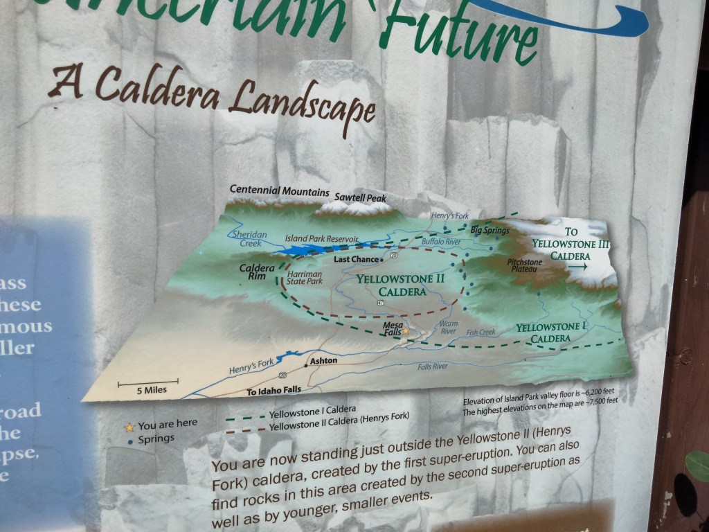
Mesa Falls, Idaho

Mesa Falls is located up in the northeastern area of Idaho. If you head due east from there, you’ll find yourself crossing the border into Wyoming and into Yellowstone National Park. It’s also near popular campsite Island Park, as well as near lots of hunting and fly fishing, well-positioned to attract people who are enjoying all the beauties of the region.

As you can see from the map above, Mesa Falls lies in part of an old caldera. The earth’s crust has moved, putting the fresh caldera under Yellowstone National Park. Hence the geysers that can be found in Yellowstone, and the eerie, sulfur-scented, brightly colored, deadly hot springs (which incidentally play a cameo role in my book The Strange Land).

This summer, I went up to Ashton, Idaho for a writing retreat. (What was I writing? That is for me to know and for you to find out!) Ashton is a relatively small, relatively remote town, but it’s touristy because of its proximity to hunting, fishing, and the Yellowstone area. I stayed in a mom ‘n’ pop motel consisting of camping cabins that have been there for ages.

On the way back from Ashton to my home stompin’ grounds, it would have made sense for me just to get on the highway and go south. But my husband has hike radar, which lets him know whenever he is within twelve hours’ drive of a good hike. This radar also works remotely, when someone he knows is in range of a good hike. So he let me know that I should go north instead, view Mesa Falls, and then head back. As it was a Sunday afternoon, I did so.

Mesa Falls is on a forest service road or something like that, so my paper map actually showed the road ending well before I got there. Thankfully, in real life it continued.

Here is proof I was there.

The hike was not at all demanding. There’s a capacious parking lot ($5 entry, envelope system), and then a series of well-maintained steps and boardwalks that bring you down to the very top of the falls, with many specially designed niches for selfies.

I did not bother to photograph the other falls-goers, but place was packed.

Now I’ll post some short videos I took of the falls.

The cliff opposite the falls was lush and green due to the permanent plume of mist that hits it.

Another Candidate for Atlantis

Photo by Ray Bilcliff on Pexels.com

https://www.ancient-origins.net/opinion-guest-authors/atlantis-revealed-platos-cautionary-tale-was-based-real-setting-003224

There have been a number of proposed sites for Atlantis. Graham Hancock has proposed Antarctica, North America, and probably some other places that I don’t know about. I’ve also heard rumors that the sunken continent could be in the Bahamas area and could explain the Bermuda Triangle phenomenon. The Disney movie Atlantis locates it off the coast of Iceland, and I have also heard people advocate the Eye of the Sahara in Mauritania. (The idea being that, before continental uplift, this site was closer to the coast, and it could have been inundated by a tsunami or something like that.) Well, the article above makes what strikes me as the most likely proposal yet.

The super-island of the Cyclades Plateau (Plato’s Atlantis) was drowned by the sea at around 8000 BC, during the rapid rise of the Mediterranean and just prior to the flooding of the Black Sea (see UNESCO study, 2009.) Incidentally, around this time, Lake Agassiz, a gigantic glacial lake in North America, also burst open and began to drain into the Atlantic. It is worth noting that Lake Agassiz covered an area larger than all the Great Lakes combined (440,000 Km 2) and at times, it contained more fresh water than all the lakes in the world today. The total fresh water outflow from this lake alone was so immense, scientists believe it raised the oceans worldwide by as much as nine feet and further produced the 8.2 kilo-year event that followed, a mini ice age that lasted 400 years! This global cataclysm at the end of the last Ice Age, which ultimately raised sea levels by 400 feet, not only erased our early history, but this could also be the event we all inadvertently refer to as the “Great Flood.”

ibid

Proposing the Cyclades Plateau as the site of Atlantis ties its inundation to a known rise in sea levels that happened right around the date that Plato says Atlantis was submerged. The article shows maps of what the plateau would have looked like and how it roughly matches Plato’s description of Atlantis (though the scale is slightly off). Of course, in my integrated version of ancient history, it went like this:

  • Pangea
  • Continental Sprint, involving cataclysmic earthquakes and also tsunamis. This is the Great Flood
  • A cold, rainy period after the Flood, leading to the Ice Age, which meant lower sea levels, coinciding with human dispersion across the newly shaped continents
  • As the Ice Age ended, we get sea levels rising and large but not worldwide local floods like those described above.

The article also suggests that this civilization was part of a larger pan-Mediterranean civilization:

Finally, a 10,000 year old Mediterranean civilization, may help explain more archaeological oddities in this region. Recent erosion and seismic tests at the Giza Plateau, indicated that the Great Sphinx may be much older structure than previously thought, and along with the site of Gobekli Tepe in Turkey, both seem to coincide with Plato’s story of Atlantis. Is it possible that Gobekli Tepe and the monument of The Great Sphinx could be remnants of the same advanced civilization Plato referenced in his story, one that was aggressively advancing against its neighbors in Africa and the Middle East, or do those belong to another culture? And what about the advanced proto-Euphratean people who descended upon the Mesopotamia around 7000 BC, from a region “unknown.” Could these enigmatic people be the refugees of the same culture who fled the Mediterranean basin and moved eastwards to escape the inundation? Undoubtedly, they could have brought with them the story of the great flood as well as the skills and technology to incite yet another great civilization, like that of ancient Sumer (just as the survivors around the Cyclades and neighboring islands may have ultimately contributed to the rise of the Minoans).

ibid

This sort of thing is catnip to me.

Finally, for the reconstructive genetics nerds among us (raises hand), the article offers bonus evidence that the residents of this Aegean Atlantis may have island-hopped their way to North America, which would explain why Haplogroup X is concentrated most heavily in the eastern Mediterranean and around the Great Lakes. (Bonus: the Great Lakes area was also the source of a particular type of copper that was used in the Mediterranean during the Bronze Age.)