Stone Age Alphabets

Today’s post comes from chapters 4 and 5 of this book.

Originally Posted as, “Writer: The World’s Third Oldest Profession”

Writing is a human practice.

Of course it is possible to have a human society without writing, but the impulse to devise a writing system, looked at historically, may have been the rule rather than the exception.

This is counter-intuitive, of course. “Symbolic logic” seems like it ought to be unnatural to humans, especially if we are thinking of humans as basically advanced animals, rather than as embodied spirits. But if we think of mind as primary, everything changes. It’s telling that reading and writing are one of the learning channels that can come naturally to people, in addition to the visual, the audio, and the kinesthetic. But I’m getting ahead of myself.

Welcome to the third post taken from Lost Civilizations of the Stone Age by Richard Rudgley. Call this the writing edition. This post hits the highlights of Rudgley’s chapters 4 and 5, pages 58 through 85.

Nah, Ancient People Didn’t Write, They were Barbarians!

The idea of writing as an exception in human history has become dogma:

The proposition that Ice Age reindeer hunters invented writing fifteen thousand years ago or more is utterly inadmissible and unthinkable. All the data that archaeologists have amassed during the last one hundred years reinforce the assumption that Sumerians and Egyptians invented true writing during the second half of the fourth millennium. The Palaeolithic-Mesolithic-Neolithic progression to civilisation is almost as fundamental an article of contemporary scientific faith as heliocentrism. Writing is the diagnostic trait … of civilisation. Writing, says I.J. Gelb, ‘distinguishes civilised man from barbarian.’ If the Ice-Age inhabitants of France and Spain invented writing thousands of years before civilisation arose in the Near East, then our most cherished beliefs about the nature of society and the course of human development would be demolished.

Allan Forbes and Thomas Crowder, quoted in Rudgley, p. 75

Of course, the demolishing of our most cherished beliefs about the course of human development is exactly what, Rudgley is arguing, is going to have to happen.

In the last few chapters I have selected only a small number of the complex sign systems that have been preserved from prehistoric times. My concentration on the Near East and more particularly on Europe should not be taken to imply that such systems did not exist elsewhere in the prehistoric world. Far from it; investigations of numerous collections of signs are being undertaken in places as far afield as the Arabian peninsula, China and Australia. Millions of prehistoric signs across the continents have already been recorded, and more and more are being discovered all the time. … It no longer seems sufficient to retain a simplistic evolutionary sequence of events leading up to the Sumerian [writing] breakthrough some 5,000 years ago.

Rudgley, p. 81

Let’s look at these complex sign systems that Rudgley has mentioned.

The Vinca Signs

I was an adult before I ever heard the phrase “Old Europe.” I was doing research for a planned book, and I was surprised to learn that in southeast Europe (between the Balkans and the Black Sea), as early as 4,000 or 5,000 BC, there were not only cities but a writing system (undeciphered) known as the Vinca signs. It turns out that these cities and this writing system were probably part of a culture that obtained over much of Europe before the coming of the Indo-Europeans, which is called Old Europe. This is the culture that Marija Gimbutas believes was “the civilization of the goddess.”

Just as a reminder, these dates for the Vinca culture are before the very first human cities and writing are supposed to have arisen, in Sumeria in Mesopotamia, about 3,000 BC.

Perhaps I didn’t hear about the Vinca signs in school because they were only discovered in Transylvania 1961. (I was born in 1976, but we all know how long it takes new archaeological findings to get interpreted, integrated into the overall system, and eventually make it into school textbooks.) After being discovered, the signs were assumed to be derived from Mesopotamian cultures such as Sumer and Crete, because it was accepted dogma that writing was first invented in Mesopotamia. Later, the tablets on which the Vinca signs were discovered were carbon-dated and found to be older than the Mesopotamian writing systems. This led to a big disagreement between those who wanted to believe the carbon dates, and those who wanted to believe the more recent dates for Old European archaeological sites, which were then conventional.

Then, in 1969, more, similar signs were discovered on a plaque in Bulgaria and dated to be 6,000 – 7,000 years old. By this time, archaeologists were beginning to accept the carbon dating of these Old European sites. But since they still did not want to admit that writing might have been invented before Sumer, most of them decided “[the signs] could not be real writing and their apparent resemblance was simply coincidental.” (Rudgley p. 63)

An archaeologist named Winn analyzed the Vinca signs and while he is not willing to go further than calling them “pre-writing,” he concludes that they are “conventionalised and standardised, and that they represent a corpus of signs known and used over a wide area for several centuries.” (Rudgley 66)

Meanwhile, Marija Gimbutas and also Harald Haarmann of the University of Helsinki both feel the Vinca signs are true writing and that they developed out of religious or magical signs, not out of economic tallies like the Sumerian alphabet.

Haarmann notes that there a number of striking parallels between the various strands of the pre-Indo-European cultural fabric – especially those related to religious symbolism and mythology. Among these common features is the use of the bull and the snake as important religious symbols. In the case of the snake it is a form of the goddess intimately intertwined with the bird goddess motif in both Old European and later Cretan iconography. The bee and the butterfly are also recurrent divine attributes, and the butterfly is represented by … the double ax. Haarmann sees the goddess mythology of Old Europe echoed in these motifs that also feature prominently in the ancient civilisation of Crete. He then traces the links between the Old European script – as found in the Vinca culture – and later systems of writing, particularly those of Crete.

Rudgley, pp. 68 – 69
Rudgley’s Figure 15 (p.70). On the left are the Vinca signs, on the right is Linear A from Crete.

Ice Age Signs

There are quite a number of symbols that appear on artifacts or are associated with paintings from the Neolithic and even the Palaeolithic period. These include crosses, spirals, dots, “lozenges” (ovals), and the zigzag, which is very common and seems to have been used to represent water. (By the way, note the zigzags among the Kachina Bridge petroglyphs.) “The discovery in the early 1970s of a bone fragment from the Mousterian site of Bacho Kiro in Bulgaria suggests that the use of the signs may date back to the time of the Neanderthals. This fragment of bone was engraved with the zigzag motif …” and apparently on purpose, not accidentally in the course of doing some other repetitive task. (Rudgley 73)

“The single V and the chevron (an inverted V) are among the most common of the recurrent motifs in the Stone Age.” (Rudgley p. 74) Gimbutas, of course, interprets the V as a symbol for the female genitals and/or Bird Goddess, but it could be just … you know … a symbol.

Archaeologist André Leroi-Gourhan has interpreted the many signs found at various Palaeolithic cave art sites not as a form of hunting magic (contra previous interpretations), but as a symbolic system. “Leroi-Gourhan admitted to us shortly before his death, ‘At Lascaux I really believed they had come very close to an alphabet.’” (Rudgley p. 77)
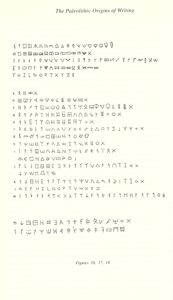
Rudgley’s Figures 16 – 18 (p. 78). Top paragraph: some of the Franco-Cantabrian (Stone Age) signs. Middle paragraph: a – hieroglyphic determinatives; b – Sumerian pictoral writing; c – Indus Valley; d – Linear A; e- Linear B; f – Cypriote; g – Proto-Sinaitic; h- Phoenician; i – Iberian; j – Etruscan; k – Greek (Western Branch); l – Roman; m – Runic. Bottom paragraph: some of the signs found on oracle bones in very ancient China.

But Can You Prove It’s Writing?

Every time some symbols are discovered that are so ancient they strain belief, anyone who doesn’t want to accept them as writing can easily go in to a number of calisthenic moves to cast doubt on this. If the item the signs are found on is in poor condition, they can question whether the marks were even intentional. Perhaps they were accidental scratches, the product of some other activity. If the marks are undeniably made by people, they can be dismissed as doodles. The Vinca signs, when first found, were speculated to have been copied randomly from Mediterranean signs by people who believed these things had mysterious power, but did not understand their meaning. Rudgley also notes that the Old European signs have been interpreted as purely magic symbols, as if a magical intent were to make them non-writing.

In short, any time we are presented with a complex system, there are always a million ways to get out of attributing it to a mind. This is doubly true if we aren’t able to interpret its meaning, but you will even see people do this with messages that they ought to be able to understand. Of course, it can also work the other way, where people see meaning in complex patterns where it wasn’t intended. Often what it comes down to is whether we want there to be a meaning there. Do we, or do we not, want to be in contact with another mind? If for whatever reason we don’t, we can always find a logical way to avoid that contact.

So in the case of apparent writing systems that we haven’t cracked and probably never will, our attitude towards them is going to depend heavily on what we believe about ancient people’s minds. Were they basically like ours, or were they different, animal? We will see more writing systems if we are expecting that they came from people. If we are not expecting to encounter people, then nothing is going to convince us that these are writing systems.

Was Adam a Writer?

My mind was blown, while taking an Old Testament Backgrounds course years ago, when I read an essay that asserted that Adam was able to write and in fact had left a written record for his descendants.

This idea seems completely loony on the face of it … until you realize that the only reason it seems loony is that we are assuming that writing is a recent, unnatural development, the product of tens of millennia of human cultural evolution, and not a characteristic human activity that is, so to speak, wired in.

The essay interpreted the early chapters of Genesis in this way. There will be a short historical record, followed by the phrase “the book of [name],” indicating that the passage immediately preceding was by that author.

PassageRecountsCloses with
Genesis 1:1 – 4:26Creation (in poetry), fall, Cain and Abel, some of Cain’s descendants, SethGen. 5:1 “the book of Adam”
Gen. 5:1b – 6:8Recap of creation of Adam, Seth’s descendants up to Noah and his sons, Nephilim, God’s resolve to wipe out mankind, God’s favor on NoahGen. 6:9a “the book of Noah”
Gen. 6:9b – 11:9Building of the ark, the Flood, emerging from the ark, the Table of Nations, the Tower of BabelGen. 11:10 “the book of Shem”
Gen. 11: 10b – 11:26Genealogy from Shem to Terah and his son AbramGen. 11:27 “the book of Terah”
Gen. 11:27b – 25:18 Terah moves his family to Haran, Terah dies, a whole bunch of stuff happens to Abram, death of Sarah, Isaac finds a wife, Abraham dies, genealogy of the IshmaelitesGen. 25:19 “the book of Abraham’s son Isaac”
Gen. 25:19b – 37:1Jacob’s entire life, death of Isaac, genealogy of EsauGen. 37:2 “the book of Jacob”
In Genesis, the author’s name comes after the notes he left.

I realize this might be a lot to accept. It’s just food for thought. It does explain why it says “the book of _________” (or, in my NIV, “this is the account of __________”), after the bulk of that person’s story.

Get it? Get it?

(By the way … for those wondering about the title of this post … prostitution is referred to as “the world’s oldest profession.” Erma Bombeck, mother and humorist, has published a book hilariously titled Motherhood: The Second Oldest Profession. The title of this post references those two, because the post is about the fact that writing is very, very old. I don’t mean to imply that a writer’s life has any necessary connection to the other two professions, although of course this does invite all kinds of clever remarks.)

A Roundup of Atlantis Theories

Photo by Pixabay on Pexels.com

Too many Atlantises. An embarrassment of Atlantises. One Atlantis, two Atlantis, red Atlantis, blue Atlantis …

Atlantis is Now Off the Coast of Cuba

This article describes an intact granite city, with pyramids, discovered off the West coast of Cuba, about 2,000 feet down, in December of 2001. As our old friend KFM, of Bad Archaeology, points out, the city would be unlikely to survive intact like this if it actually dropped dramatically from what is now sea level, as Plato seems to describe. The article points out that there is another city, the Yonaguni Monument, off the coast of Japan, and Graham Hancock in his book, Underworld, points out that there are submerged megalithic cities in many places around the world, including off the coast of India. (Hancock has cycled through seriously advancing a number of different Atlantis theories, so he will be sort of the workhorse of this post.)

It seems to me that the city off the coast of Cuba is part of a worldwide phenomenon where sea levels were once much lower. We can include in this phenomenon Doggerland (which will make another appearance later in this post), and the land bridges known to have once connected Asia to the Americas and the Indonesian islands to the mainland.

If you are an old-earth believer and have to juggle millions of years, multiple cooling and warming periods, slow but somehow effective continental drift, and some confusing archeological indications that humans were perhaps around well before they should have been … good luck. As someone who believes that the history of the earth is measured in thousands or tens of thousands, but not millions or billions of years, my guess is that this period of low sea levels plus advanced civilization came right after the Great Flood.

You would have a much colder, rainier climate as the earth adjusted to the recent cataclysm (about this more in a minute). You would have had frequent snow and rain storms, with all this precipitation getting frozen in the rapidly forming ice sheets, causing Earth’s water supply to be greatly reduced. Meanwhile, you would have Noah’s children and grandchildren branching out as quickly as possible, building megalithic cities wherever they went, still remembering the techniques and technology (and possibly still assisted by the giants and gods) that they had seen pre-Flood. This period of low sea levels would have had to last long enough for people to disperse and to build, but it need not have been very long. It could have a been a matter of a few hundred to a thousand years. As the climate stabilized, you would have had floods covering settlements and civilizations in different parts of the world. This, I believe, is the reason we have an embarrassment of Atlantises.

There have also been assertions that the reason for the Bermuda Triangle phenomenon is that Atlantis lies underneath it. (Note that the west coast of Cuba is outside of the Bermuda Triangle.) This theory certainly appeals to those who are interested in the potential paranormal effects of the lost city, but I do not know of any actual submerged city found in the Bermuda Triangle area. (If you do, please enlighten me in the comments. I’m always looking for another Atlantis to add to my collection.) This article discusses how ocean-floor mapping technology can create lines that look like city streets.

Atlantis as Antarctica

Graham Hancock makes the case for this in his book Fingerprints of the Gods. He posits that the evidence points to an ancient, advanced civilization which was destroyed by a cataclysm, and asserts that the refugees from it seeded their scientific knowledge, in code form, by creating new religious cults all around the world that featured certain sacred numbers.

If you’ve been reading Out of Babel for a while, you know my assessment of all of this is that it’s right, but not in the way that Hancock thinks it is. Among other things, his scientific materialism and evolutionary beliefs make it impossible for him to imagine that people groups like the Maya, for example, would have come up with advanced mathematics on their own, so he needs to posit a more “advanced” civilization bringing these things from without.

Anyway. For his advanced ancient civilization, Hancock realizes he needs a continent-sized homeland (because, again, his evolutionary beliefs about man require that such a civilization develop gradually, over millennia, from hunter-gatherers to farmers and so on). Antarctica is a good candidate because it’s an entire continent; there is some evidence that it was mapped before it was quite so covered in ice; its general pre-ice outline corresponds roughly to Plato’s description of Atlantis; and there is a theory available for how it could have gone from being in a temperate part of the Atlantic, to being at the South Pole, in a relatively short amount of time. Hancock calls this “earth crust slippage” and posits that it happened about 20,000 B.C.

Now for the version I find more plausible: Creation scientist Dr. Kurt Wise presents his team’s model for “continental sprint” in this video. I find Dr. Wise’s model persuasive as a model of the Great Flood, and as we will discuss, it could explain the Atlantis legend wherever in the world Atlantis proves to have been. However, even if you buy into “continental sprint,” it does not follow that Plato was describing Antarctica when he wrote about Atlantis. If all the land on the earth were breaking up, the ultimate fate of that portion that later became Antarctica would seem like a minor detail.

Atlantis as North America

This one was put forward by Graham Hancock, after he abandoned his Antarctica theory, in his book America Before, a review of which I react to here. Although weak, the theory relies on the fact that there are large structures, either megalithic or earthworks, which align to different astronomical features and/or function as observatories, all around the world, including in North America. For example, the pyramid complex at Teotihuacan appears to be a model of the solar system; the Giza Plateau appears to be a model of Orion, and Serpent Mound in Ohio, which sites towards the sunrise at solstices, may be according to Hancock a model of the constellation Draco.

All that to say, anywhere you can find a large astronomical structure, you can make a case for Atlantis, and Hancock has made that case for North America.

Atlantis as the Cyclades Plateau in the Aegean

This article, which I posted last summer, asserts that Plato’s descriptions of Atlantis are admirably matched by the Cyclades Plateau (now the Cyclades islands), which would have existed when sea levels were 400 feet lower than they are now. The Cyclades Plateau is a rather large formation right in the middle of the Aegean. (If we consider that lower sea levels would have also expanded the coastlines of the rest of Greece, then it would have been even closer to the mainland.) This is an attractive theory in terms of its being what Plato was actually talking about (since he makes Atlantis contemporary with Athens), but it does depend upon this:

Recently, a four year study that included a thorough analysis of Plato’s work established that serious errors by early translators allowed for the mixed messages in the translated document.

Atlantis as Part of Doggerland

Yet another underwater location that used to be inhabited when sea levels were lower, Doggerland was a vast region that stretched between England, France, Holland, and Scandanavia, and is now the relatively shallow southern part of the North Sea. Archaeological discoveries have handily established that this area was once inhabited, here and here among others. As with other now-submerged human habitations, the reader’s preconceptions will determine how long ago you believe it was inhabited, and for how long.

This article describes an entire book which puts forth a detailed theory Plato was describing Doggerland. Apparently, Atlantis had a large, roughly rectangular plain surrounded by “ditches,” which the author thinks could also be translated “dikes.” He imagines the inhabitants of AtlantiDoggerland using these dikes to keep the sea back from a certain region of Doggerland for a period of time. Without some very expensive underwater archeological expeditions (in a notoriously dangerous sea), there is no way to confirm whether the ruins of a large city lie where this theory would predict. The maps are well worth looking at.

Atlantis as the Richat Structure

The Richat Structure, of the “Eye of the Sahara,” is a large (c. 40 km) formation of concentric rings of stone located in present-day Mauritania. Because of its size and remote location, it is hard to spot except from orbit.

Depending upon how you calculate, the structure matches the recorded dimensions of Atlantis quite well. There are also, of course, explanations about how this structure could have formed geologically. I’m not enough of an expert to assess these, but I am more skeptical of geological explanations than I used to be, now that I’ve seen “mountains” that turned out to be pyramids with insides, and geologists’ attempts to explain how a single fossilized tree could cross-cut millions of years’ worth of sedimentary rock layers. In other words, could go either way.

For the Richat structure to be Atlantis, we have to imagine that it was once nearer to coast and was inundated by a tsunami or something of that nature. This theory actually works fairly well with the geological model that Dr. Kurt Wise presents above. “Continental sprint” would have included many earthquakes and resultant tsunamis. Africa, in the model, does not move as much as the other pieces of Pangea, but it would still have undergone earthquakes and, possibly, some uplift.

On this theory, with his tale of Atlantis Plato somehow retained a memory of a pre-Flood incident (and read Athens back into it?). Below is a video of Pastor Joel Webbon discussing the theory with Brian Suave and Ben Garrett of Haunted Cosmos. They get into local lore around the Richat structure, how this dovetails with Greek legends about Atlantis, and how this all could have been plausible in a pre-Flood world haunted by gods and nephilim.

Conclusion

When I first started composing this post, I thought I was going to come out in support of the Richat Structure. Now, I just don’t know. The Haunted Cosmos guys make it sound very plausible, but a few of the other candidates are also plausible (some less so). There does not seem to be any way to “find” Atlantis without sacrificing at least some of what Plato has to say about it. (For example, Athens existed before the Flood? Before there was a Europe?) This makes it really difficult to favor any one theory (although we can probably discard others). What is clear, is that the prehistoric world had many sophisticated cities, lots of things built with megaliths, pyramids on almost every continent, and that there was a period when many human settlements were submerged as sea levels rose. The details are a matter of speculation, of the kind suitable for someone writing a novel.

A Retired French Mining CEO and His Theory that Doggerland was Atlantis

Some day, we are going to have to do a long post about Doggerland. Right now is a busy time of year, so I don’t have the time for that at the moment, but long story short, Doggerland has everything.

Doggerland was an area that you probably know as “the bottom of the North Sea.” Apparently, there is a shallow area there, with evidence that when sea levels were lower, it was once not only exposed but inhabited. This vast area of land would have joined England and Ireland to what is now Holland and Denmark. The proximity to Holland, plus the theory that Doggerland is the setting for The Lord of the Rings, are what I mean when I say this place has everything.

For now, let’s put a pin in this article. Jean Deruelle, the French guy with the theory, has detailed ideas about exactly what the inhabitants of Doggerland got up to. He assumes (reasonably, I think) that they were part of the Old European megalithic culture. The article also includes lots of cool speculative maps of Doggerland in various stages of submersion by the sea. We can argue about the exact timing of it all, later.

Yay Neanderthals!

What’s the most entertaining thing about this story? Is it …

  • the neat little tidbits about Neanderthal genetics?
  • the big reveal that Neanderthals, Denisovans, and so-called “modern humans” are all actually the same species?
  • the total blindness to the way this fact contradicts the evolutionary narrative?
  • the researchers’ discovering that close kin used to intermarry in the distant past, just like we’re told in Genesis?
  • their attempts to minimize this same fact?

The “Oldest Dutch Art”

… is zigzags carved onto a possibly 13,500-year-old bison bone retrieved from Doggerland.

Retrieved by Dutch fishermen.

“The oldest Dutch art,” haha, get it?

Doggerland was a fertile area inhabited by people when sea levels were much lower. It lay under what is now the North Sea. Unlike the map in the linked article, some maps show it being a vast lowland area essentially joining England with what is today Scandanavia. These maps also often show England joined to France and Ireland. Europe’s current rivers are just the headwaters of a larger river system. Of course, no one knows exactly what it would have looked like, but it’s fun to speculate.

On an evolutionary timescale, Doggerland was inhabited over millennia, millennia ago. On a young earth/catastrophic flood timescale, it could have been settled over decades or centuries by people dispersing after the flood, when the climate was cool and rainy, large glaciers formed rapidly, and sea levels were consequently much lower, exposing land bridges all over the world that facilitated humanity’s dispersion. There could have been a relatively short period of time (a few centuries?) before the climate stabilized, the glaciers melted, and sea levels rose, marooning people wherever they had ended up.

As a Dutch person myself, I think it’s incredibly clever that they call this the “oldest Dutch work of art.” I mean, given that the Dutch have reclaimed a good part of their country from the sea, why don’t we just go ahead and let them have as much of Doggerland as they can manage?

However, I disagree with some of the experts in the article that the only possible use we can imagine for zigzags is artistic or “ritual.” Following Richard M. Rudgley, other possible are uses are a calendar, music, or some other kind of scientific notation.

Altai Throat Singing

The Altai mountains are in central Asia, north of the Himalayas, around the area where countries such as China, Mongolia, Russia, and Kazakstan meet. They are not too far from the stompin’ grounds of the horse-riding Central Asian tribes such as the Scythians and Parthians, part of the same culture area that gave rise to the early Indo-Europeans with their kurgans, before they moved west into Europe proper. That’s why these guys look sort of European and sort of Asian. People who live here have looked like this for thousands of years.

The Altai mountains are an old range of mountains (left over from Pangea?), not created by whatever event caused the Himalayas. Hence, they are low and rolling. I had to (lightly) research this part of the world when I went to write The Long Guest. My characters called them the Gentle Mountains. They had a lodge there for some years before moving on to the Gobi desert (which possibly didn’t actually exist in the immediate post-flood years in which my story is set, but we will ignore that. Onward!)

I thought this was a perfect video to share on a winter’s day. Are these people cool or what? I love how he warms up for throat singing by making horse noises.

As with many cultures, my imagination is very attracted to their way of life, but I would probably hate it if I had to actually live that way, not being tough enough.

Another Candidate for Atlantis

Photo by Ray Bilcliff on Pexels.com

https://www.ancient-origins.net/opinion-guest-authors/atlantis-revealed-platos-cautionary-tale-was-based-real-setting-003224

There have been a number of proposed sites for Atlantis. Graham Hancock has proposed Antarctica, North America, and probably some other places that I don’t know about. I’ve also heard rumors that the sunken continent could be in the Bahamas area and could explain the Bermuda Triangle phenomenon. The Disney movie Atlantis locates it off the coast of Iceland, and I have also heard people advocate the Eye of the Sahara in Mauritania. (The idea being that, before continental uplift, this site was closer to the coast, and it could have been inundated by a tsunami or something like that.) Well, the article above makes what strikes me as the most likely proposal yet.

The super-island of the Cyclades Plateau (Plato’s Atlantis) was drowned by the sea at around 8000 BC, during the rapid rise of the Mediterranean and just prior to the flooding of the Black Sea (see UNESCO study, 2009.) Incidentally, around this time, Lake Agassiz, a gigantic glacial lake in North America, also burst open and began to drain into the Atlantic. It is worth noting that Lake Agassiz covered an area larger than all the Great Lakes combined (440,000 Km 2) and at times, it contained more fresh water than all the lakes in the world today. The total fresh water outflow from this lake alone was so immense, scientists believe it raised the oceans worldwide by as much as nine feet and further produced the 8.2 kilo-year event that followed, a mini ice age that lasted 400 years! This global cataclysm at the end of the last Ice Age, which ultimately raised sea levels by 400 feet, not only erased our early history, but this could also be the event we all inadvertently refer to as the “Great Flood.”

ibid

Proposing the Cyclades Plateau as the site of Atlantis ties its inundation to a known rise in sea levels that happened right around the date that Plato says Atlantis was submerged. The article shows maps of what the plateau would have looked like and how it roughly matches Plato’s description of Atlantis (though the scale is slightly off). Of course, in my integrated version of ancient history, it went like this:

  • Pangea
  • Continental Sprint, involving cataclysmic earthquakes and also tsunamis. This is the Great Flood
  • A cold, rainy period after the Flood, leading to the Ice Age, which meant lower sea levels, coinciding with human dispersion across the newly shaped continents
  • As the Ice Age ended, we get sea levels rising and large but not worldwide local floods like those described above.

The article also suggests that this civilization was part of a larger pan-Mediterranean civilization:

Finally, a 10,000 year old Mediterranean civilization, may help explain more archaeological oddities in this region. Recent erosion and seismic tests at the Giza Plateau, indicated that the Great Sphinx may be much older structure than previously thought, and along with the site of Gobekli Tepe in Turkey, both seem to coincide with Plato’s story of Atlantis. Is it possible that Gobekli Tepe and the monument of The Great Sphinx could be remnants of the same advanced civilization Plato referenced in his story, one that was aggressively advancing against its neighbors in Africa and the Middle East, or do those belong to another culture? And what about the advanced proto-Euphratean people who descended upon the Mesopotamia around 7000 BC, from a region “unknown.” Could these enigmatic people be the refugees of the same culture who fled the Mediterranean basin and moved eastwards to escape the inundation? Undoubtedly, they could have brought with them the story of the great flood as well as the skills and technology to incite yet another great civilization, like that of ancient Sumer (just as the survivors around the Cyclades and neighboring islands may have ultimately contributed to the rise of the Minoans).

ibid

This sort of thing is catnip to me.

Finally, for the reconstructive genetics nerds among us (raises hand), the article offers bonus evidence that the residents of this Aegean Atlantis may have island-hopped their way to North America, which would explain why Haplogroup X is concentrated most heavily in the eastern Mediterranean and around the Great Lakes. (Bonus: the Great Lakes area was also the source of a particular type of copper that was used in the Mediterranean during the Bronze Age.)

The Human Impulse to Make Stone Spheres for Some Reason

A while back, I blogged about decorative, marble-sized clay spheres that were found at the Poverty Point archaeological site (“Poverty Point objects”), which turned out to have been used for cooking.

That’s what I thought I had stumbled upon when I first saw this headline about the larger, billiard-ball sized stone spheres that have been found in association with recumbent stone circles in Scotland.

But these spheres turn out to be, if possible, more sophisticated than the Poverty Point objects. In this and the follow-up article, there are a number of theories about the possible purpose of the spheres:

  • Projectiles for hunting or war. However, the spheres don’t appear to have taken any damage from being thrown.
  • Perhaps the small spheres were used to roll the megaliths, though again, if they are not damaged this seems unlikely (and for the record, I think this is a dumb theory).
  • Fishing weights
  • Weights and measures for other purposes, since some of them seem very standardized.
  • Divination, by rolling them on the ground.
  • The stones were used to roll around in a bowl of sand and produce interesting sand art. (Hmmm.)
  • Representations of pollen, or of atoms. (See my post that points out that the caduceus may be a representation of a DNA molecule.)
  • The spheres may have been a “portfolio” made by skilled stoneworkers in order to demonstrate what they were capable of. (Now we are getting somewhere!) In connection with this, the author of the article mentions that he has seen at least one stone sphere (and spirals) reminiscent of those in Scotland, while on a trip to a pyramid site in Bolivia. He asks, “Did the megalithic Scottish stonemasons really make their way to South America in prehistory?” That is certainly possible, but I think it could simply speak to a worldwide, pre-Flood or immediately post-Flood culture of megaliths, pyramids, and advanced knowledge of astronomy.
  • The spheres could be models of the Platonic Solids. “What we have are objects clearly indicative of a degree of mathematical ability so far denied to Neolithic man by any archaeologist or mathematical historian.”
  • Given their sophisticated geometry, the author of the article favors the idea that these spheres were used in the study of spherical geometry. This leads on to the suggestion that they could have been models used to study the geometry of the earth, perhaps for navigation, astronomy, or detecting ley lines. Regarding navigation, see the Out of Babel posts on the Antikythera Mechanism, and possible ancient maps. Regarding astronomy, recall that in the more recent ancient world, the celestial equator, equinoxes, and the procession of the stars were conceived of as a structure of intersecting hoops surrounding the earth.
  • Finally, there’s a theory that the spheres were used as “energy channels” to focus magnetic properties either into fields for increased soil fertility, or into human bodies for healing. This one seems to me a little weird and unnecessary because I like the spherical geometry thought … but I hesitate to mock it too hard, because quite a few very weird ideas that I would at first dismiss, have turned out to have been at least widely accepted in the ancient world, if not actually functional in the ancient world though not in the modern world.

Long story short, add one more tick mark to the column “ancient people were not only much smarter than we think, but also much smarter than we are now” … which has been a constant drum beat on this blog.

I started out studying the ancient world so that I could write fiction about it. I still enjoy doing that, but the more I learn, the more I realize that my fiction is going to be very inaccurate because I truly have no idea what those people were getting up to back then, and it seems that even if I had been present, I would hardly have been capable of understanding it.

But buy my books anyway.

The “This Is Your Story” Book Tag

I shamelessly stole this tag from Bookstooge and The Orangutan Librarian … oh wait, it looks like TOL actually did tag me. Technically. Thanks to  Sheri Dye for creating this fab tag!

The Rules

  • Link back to the creator @ReadBetwixtWords
  • Answer each question by using your favorite (or TBR) book covers, characters, and stories
  • Tag a friend or two
  • And have fun with it!

QUESTIONS

Here they come:

AUTHOR – WHO’S WRITING YOUR STORY?

Andrew Klavan. He writes older female characters pretty well, plus he totally adores women, so he will make me seem like a much better person than I actually am finally give me the credit I’m due!

On the down side, his stories tend to be rather dark and violent, so buckle up.

WORLD – WHAT LITERARY WORLD IS YOUR STORY PART OF?

It’s a paranormal portal fantasy where I go to an archaeological site to research a book, unwisely step along a ley line, and end up in Atlantis.

Mixed with a Miss Marple mystery.

ROMANCE – WHO WILL BE YOUR LOVE-INTEREST?

I’m a married woman, and besides I’m too old for romance. The romances will take place among secondary characters, the way they always do in Brother Cadfael mysteries. My grown sons will each get married in the course of the book, plus there will be at least one secondary romance in Atlantis, but it will end tragically.

APPEARANCE – WHAT WILL YOUR CHARACTER LOOK LIKE?

Myself, but about 20 years older. I’ll be a spry little old lady with wild, flyaway hair. Sort of a Good Witch look. Also, my nose will be bigger than current.

SIDEKICK – WHAT CHARACTER/CREATURE WOULD YOU HAVE BY YOUR SIDE?

My niece, a very cool person who just happened to meet up with me at Newgrange because she was on a study program in England.

I have a lot of nieces. I won’t say which one I have in mind, but she knows who she is.

GOOD, EVIL, OR GRAY – WHERE DOES YOUR CHARACTER STAND?

Twenty years from now, I will be so sanctified and refined by the sufferings of life that I am the goodest of the good, hidden underneath a thick layer of Old Lady bitterness and cynicism.

DESIGNATION – WHAT WILL YOU BE? (HUMAN, FAIRY, PIRATE, PRINCESS, ETC..)

Wait a minute … we have options other than human? Why wasn’t this mentioned earlier???

OPPOSITION – WHO WILL BE YOUR NEMESIS?

Since this is an Andrew Klavan novel, there will be two nemesises (nemesi?). In this world, it will be Klaus Schwab. In Atlantis, it will be a being of light that is going to help bring humanity to a higher plane. Later, it turns out that Schwab is working for the being of light.

THE ENDING – HOW DOES YOUR STORY END? SPOILER ALERT!

Like they all end: I die.

But not before I make it back to the 21st century in time to help expose Klaus Schwab (working together with my niece and an unlikely band of misfits that includes James Lindsey, Andrew Klavan, and my pastor. Klavan will be about 100 years old at this point, unless he has also engaged in time travel).

And, we all know what happens to Atlantis.

(What’s that you say?

Plotholes, schmotholes!)