Dr. Doug Petrovich identifies the pre-Uruk-dispersion city of Eridu as the original site of Babel. It is in southern Mesopotamia, farther south than the later city which was also called Babel.
His own translation of the Hebrew word usually rendered as “tower” notes that this is a word that can also mean temple or platform (such as a platform where ceremonies would be performed). In fact, what we find at Eridu is an Ancient-Near-Eastern-style temple that was torn down and rebuilt bigger a number of times, then had a massive platform added in front of it that dwarfed the temple itself. This was then abandoned abruptly, sat there for about 1000 years, and then Sumerians from the city of Ur attempted to add to or restore it.
That is what I remember from the video after having watched it a few days ago. I don’t believe I got any details wrong, but you can check by watching it yourself. Dr. Petrovich has a much dryer style of delivery than the inimitable geologist Dr. Kurt Wise.
Obviously, Dr. Petrovich’s interpretation of the “tower” of Babel differs from the treatment I gave it in my own books: it is farther south, and though big, it is not an actual skyscraper-type tower. Still, I can’t get over the coolness of the idea that archaeologists might actually have found it. I dealt with this problem in The Long Guest by having a year of heavy rains almost completely destroy the tower (made of mud bricks) after it was abandoned. If I had followed Dr. Petrovich, I need not have bothered.
Everyone has to have their 15 minutes of appearing on video, right?
My wonderful sister, who has a YouTube channel, graciously offered to interview me about The Scattering Trilogy. Here, you can watch us chat about genres, languages, and paganism, and how it all fits in.
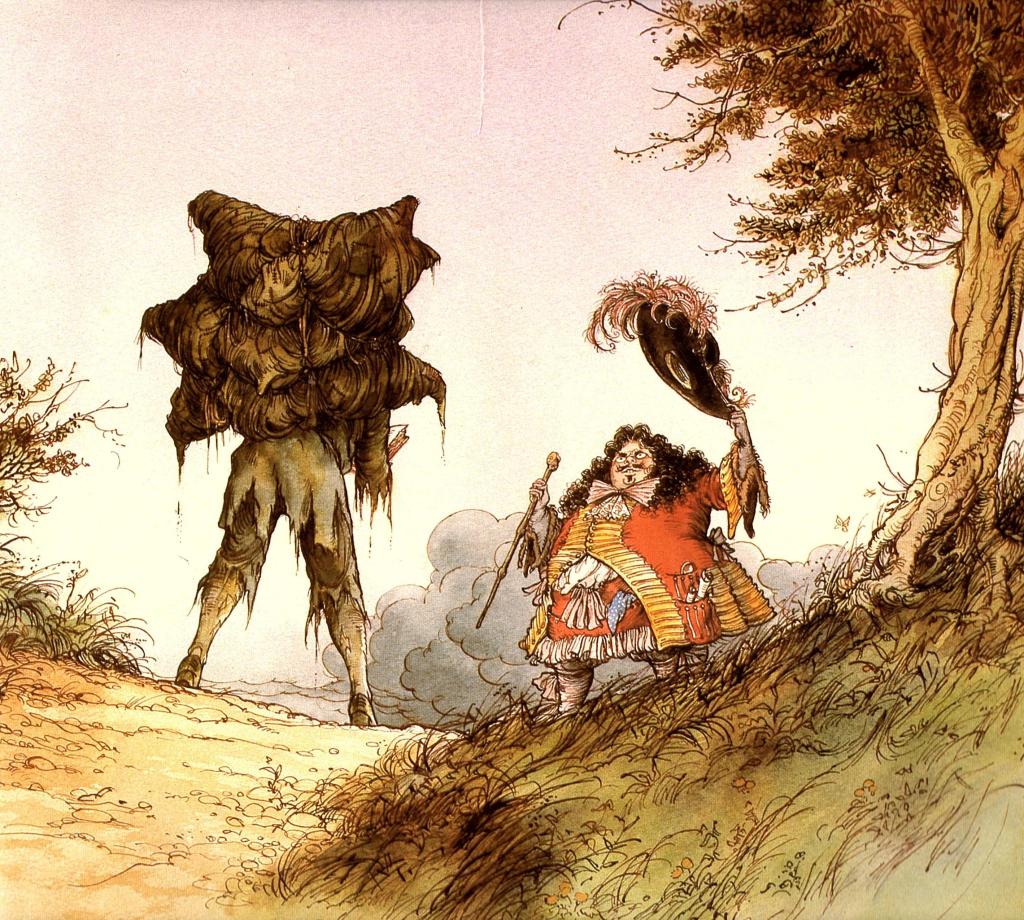
Pilgrim’s family climb over the stile to call him back. From Dangerous Journey.
This is why I love home schooling. I learn so much.
I can’t say the 1600s (also known as the Seventeenth Century) were covered very well in my own education. I heard, dimly, of one or two events, like the First Thanksgiving and the Salem Witch Trials (which took place near the end of the century, 1692). I was exposed to a kids’ version of Pilgrim’s Progress. In other contexts, unconnected from history lessons, I heard the names of a few notables from the century such as Bach, and saw a picture of a Cavalier or two. But all these things were floating around without any context. I had no idea of how they were connected to each other, or even that they were happening around the same time. They were, frankly, all mixed up with things from the following century.
Now [this post written in 2019], studying it in chronological order with my kids, I have to say that I like learning about the 1600s. A lot of really horrible things happened, like the beginnings of colonization and of the Atlantic slave trade. But many really interesting things were happening too. Some of them, like the English Civil War, I had barely heard of. Also, this was an amazing century for music and art.
And the clothes. My goodness, the clothes! Long curly wigs, big white collars, hundreds of buttons! They must have been so inconvenient to wear (and to wash. Especially in brackish water. After you’d been on the Mayflower and hadn’t washed for three months). But they look so cool, so dignified, in illustrations! And there is the contrast between the colorful, swashbuckling Cavalier look and the restrained, clean-lined, monochromatic Puritan Sunday best.
The pictures in this post are taken from Alan Parry’s 1985 illustrations of Pilgrim’s Progress in the children’s book Dangerous Journey. I love the 17th-century clothing and the way that the illustrations suggest etchings, which were being done in the 17th century by the likes of Rembrandt.
Pilgrim, still wearing the burden on his back, meets Mr. Worldly Wise.
A few highlights of the 17th Century:
The founding of Jamestown, Virginia (1607). Jamestown was first run along communist lines, and it was a disaster. In order to get the ne’er-do-wells there to actually build a fort, grow their own food, etc., they needed John Smith to whip them into shape, plus a boatload of mail-order brides (really!), plus allowing private property.
The founding of Plymouth, Massachusetts (1620). Interestingly, the Massachusetts colony also tried communism. Their contract with the London Company stipulated that for seven years, the products of the colony were to be put in a common fund to be shared by all the colonists. But after only three years they had to stop this arrangement and give each family their own plot of farm land.
The English Civil War (1642 – 1651). Cavaliers (Royalists) vs. Roundheads (Parliamentarians). The English got rid of their tyrant (Charles I), only to have him replaced by an ideologue (Oliver Cromwell). When Cromwell died, they were relieved to go back to just a regular tyrant (Charles II).
John Bunyan (1628 – 1688). Bunyan was a traveling tinker, yet he wrote one of the world’s top best sellers, Pilgrim’s Progress. He also wrote his spiritual autobiography, Grace Abounding to the Chief of Sinners. (Is that a great title for an autobiography, or what?)
The Great Fire of London (1666). It burned for three days. Four-fifths of London burned down. “Hundreds of people fled to St. Paul’s Cathedral. But the flames swept up the walls, burning timbers and melting the lead in the roof until it ran down toward the river like molten lava. The stones in the walls themselves began to explode from the heat!” (Wise Bauer 126).
Rembrandt van Rijn (1606 – 1669). Art!
Vivaldi (1678 – 1741), Bach (1685 – 1750), and Handel (1685 – 1759). I might be sort of cheating, including Bach and Handel in this century, since they were only 15 when it closed. But both these geniuses were born and educated during the 1600s.
Sources
Bauer, Susan Wise. The Story of the World: History for the Classical Child, vol. 3: Early Modern Times: from Elizabeth the First to the Forty-Niners. Well-Trained Mind Press, 2004.
Demar, Gary, et. al. Building a City on a Hill. American Vision, 1997, 2005.
Hannula, Richard. Trial and Triumph: Stories from Church History. Canon Press, 1999. “Chapter 30: John Bunyan,” p. 181 ff.
Hunkin, Oliver, ed., & Alan Parry, illustrator. Dangerous Journey. Text copyright 1985 Yorkshire Television Ltd.. Worldwide coedition by Lion Hudson plc, Mayfield House, Oxford. US edition by Eerdmans, Grand Rapids, MI, 2012.
Stebbing, Barry. God & the History of Art I. How Great Thou ART Publications. “Rembrandt van Rijn: A Man of Sorrows,” p. 65 ff.
For a tag, you are given a series of prompts around a particular theme, and you answer the prompts, usually with the names of books you’ve read.
Para que lo sepas, I had to restrain myself from naming one of my own books for almost every one of these prompts. After all, the Scattering Trilogy is multigenerational; life-affirming; about rebirth; includes a fair amount of food, etc. Anyway, that’s en mi opinion. But I will do this tag like a normal person and name books by other people.
Photo by Chait Goli on Pexels.com
The Day of the Dead is all about remembering and honoring past generations.
Name a book with an intergenerational cast or a strong focus on family.
Pavilion of Women, by Pearl Buck. Buck is a master at sliding seamlessly through time in her stories. In the opening scene, Madame Wu is sitting in her chamber on the morning of her fortieth birthday. Her maidservant comes in to comb her hair, and suddenly we are in this same bedroom twenty-four years ago, on the morning after Madam Wu married Mr. Wu, and the same maidservant has come in, and she is nervous as a cat around her new mistress, because she knows that she just had sex for the first time. Now, twenty-four years later again, the servant is much more at ease with Madam Wu, but she does not know that her mistress has decided that as of her fortieth birthday, she will stop living to keep the Wu household running smoothly, and start living for herself. She just has to get through the party.
Dia de los Muertos is an important Mexican holiday. Name a book that takes place in Mexico or includes Mexican culture.
I’ve been slo-mo bingeing on books about the archaeology of Mesoamerica. Of course, with books like these, which are about as old as I am, you need to supplement them with current articles, since new discoveries and analyses keep being made.
This holiday is often celebrated with vibrant, colorful imagery and sugar skulls. Name a book with a cover as visually-interesting and colorful as a sugar skull.
I will never stop promoting the art of Trina Schart Hyman.
Food is an important part of the Dia de los Muertos celebration. Food is set out on altars for the spirits of departed family members.
Tell us a book where food really makes the story!
The No. Ladies’ Detective Agency books. These are written from multiple perspectives, but arguably the main character is Precious Ramotswe, founder of the No. Ladies’ Detective Agency, the only female-run detective agency in Botswana. Mma Ramotswe is fat (“traditionally built”), and while not unusually greedy, she does enjoy her food and thinks about it fairly often. She always likes to visit the formidable Mma Potokwane, who runs an orphanage, because although Mma Potokwane is sure to ask for some kind of favor for her orphans, she always serves Mma Ramotswe a generous piece of cake, sometimes two.
“Some people very clearly and obviously would like to eat more cake. It might as well be printed on their forehead: Greedy person.” Ah yes, that would be me.
Dia de los Muertos is not only celebrated in Mexico, but also in Central and South America. Name a book that takes place in Central or South America or has a Central or South American author.
I’ve read a lot of missionary stories, but Bruchko is one of the most remarkable. It takes place among the Motilone, who live in the jungle somewhere along the border of Venezuela and Colombia.
In addition to sugar skulls, flowers and butterflies are also symbols of this holiday. Tell us a book with flowers or butterflies on the cover
Nailed it.
The Day of the Dead is about celebrating life. Name a book that celebrates life.
The book of Job, in the Bible.
You think I’m kidding? No, listen.
Job isn’t about Job patiently putting up with suffering, proving what a good person he is, and then God rewards him. That’s the caricature, but it’s almost the opposite of the real theme of the book.
The consensus in Ancient Near Eastern wisdom literature was that, since God is just, if anything bad happens to anyone, it must be their fault. This is still, by the way, the essence of human wisdom in many parts of the globe, especially in Hinduism. It is also many people’s instinct when we see a horrible disaster befall someone, to find some way that the unfortunate person brought it upon themselves, or “how this could have been avoided.” It makes us feel a little more in control.
The book of Job exists to subvert this universally accepted bit of “wisdom.”
Job starts out as a model of the good person in the Ancient Near East. He has seven sons (the perfect number!), and three daughters; he offers regular animal sacrifices to God. And he’s rich, as he should be. Everything is making sense, see?
Now we take this model Good Person and visit all kinds of punishments on him. And this must be an expose, right? It must be Justice Falling At Last!
Job’s three “friends” show up, and they proceed to preach some very reasonable, theologically sound sermons just like you could hear in any of the wisdom literature of the day. God is just. He rewards the righteous and punishes the wicked. Therefore you must have deserved this somehow. If you say you haven’t, you are defying God! Beat that!
Their logic is flawless. And God sides with Job against them. “You have not spoken of me what is right, as my servant Job has.”
If that’s not life-affirming, I don’t know what is.
It is also a day of remembering loved ones who passed on. Name a book that was either given to you or reminds you of a loved one who passed away.
Let me tell you about Alice.
I can tell you all about her now, because she’s with the Lord. No privacy risk or anything like that. I’d post a picture if I had one, but I don’t.
By the time I knew Alice, she was in her late eighties. (I was in my late teens.) She mentored me for a few years before she got dementia. She was a sweet, little old German-American lady, with a sly sense of humor. She could do impressions, but used this skill judiciously. Once she said to me, “You want to know why I never married?” And then, for an answer, she quoted the King James verse, but with different punctuation: “I would not have thee, ignorant brethren.” Props to you if you get that joke.
The “brethren” that she “would not have” were certainly missing out, because Alice was a treasure. Perhaps they overlooked her good qualities because of a facial deformity. She had been bitten on the cheek by a horse as a child, and it wasn’t until she was an adult that she was able to afford corrective surgery.
Anyway, one day when I was at Alice’s house, I picked up the book The Holiness of God by R.C. Sproul. She encouraged me to borrow it. I expected it to be a dry, academic read, because it was on a lofty theological topic. But no, it was written for the layperson, and was very accessible. A page-turner, in fact. To this day I associate that book with Alice.
El flor del Muerto – The flower of the dead. Marigolds are used in massive quantities on the Day of the Dead. These flowers represent the sun and rebirth. Also believe to guide the spirits back home. Name a book about rebirth.
The Great Good Thing, by Andrew Klavan. Unfortunately, I have lent my copy out, so I can’t show you a picture. This is the story of how Klavan grew up as secular Jew on Long Island, ran away from home, lived as a hobo for several years, became a hard-boiled noir crime writer and a Hollywood success, and then became a Christian at the age of 50. He is now a Christian, Jewish, hard-boiled noir crime writer who also writes YA and fantasy.
If you want to read a novel about rebirth, try Identity Man, also by Andrew Klavan.
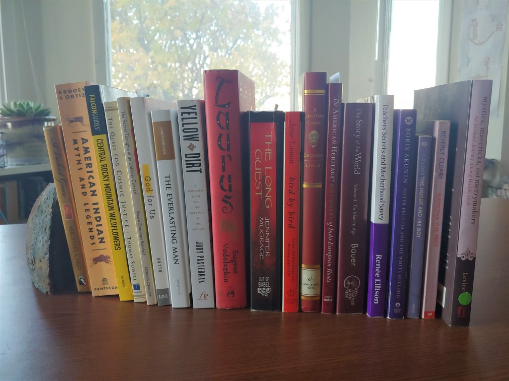
Colors are used as a form of symbolism in the decorations and sugar skulls. Some of the colors used in association with Dia de los Muertos are yellow (unity), white (hope and purity), red (blood and life), purple (mourning), and pink (happiness).
Take a photo of some book spines in the Dia de los Muertos colors!
And a happy Dia de los Muertos to all who celebrate ❤
P.S. Disclaimer about Memorializing Our Dead
If anyone feels uncomfortable with me doing this tag, because, you know, skulls and dead people and paganism, I get it.
Let me reiterate a point I have made before, that pagan practices (especially old ones with deep roots) often fulfill basic human needs that every society needs to fulfill, such as celebration, marking the seasons, etc. In this case, the basic human need is to continue to feel a connection to, and to honor, our loved ones who have died. In a way, it’s part of the mourning process. Modern American society is terrible at this, sorry to say. The only formal time to remember the person is during the funeral and burial, after which the mourners are expected to basically stop talking about the person except to very close friends or relatives. Bringing them up, or continuing to visibly grieve, causes that sin of all sins, social awkwardness. This is pretty harsh, and it does not match well with the way that grieving goes for most people.
There are ways to provide for ongoing grieving, honoring, and remembering that are not ancestor worship. For example, in Indonesia, the Muslims have memorial services at 30 days, 100 days, and a year after the death. The people groups of Kalimantan (pagan and sometimes Christian as well) have a second, larger, funeral ceremony, usually a year later, when they dig up the person’s bones and re-inter them in an ossuary with the bones of the family. The Christians will have about a week or so of viewing services while they wait for people to gather for the funeral; then the graveside service; then that night an additional “comfort” service. Most of these take place at the family’s house, and they mean the house is filled with people, songs, and food. The family is not left alone. The people who attend don’t have to say or do anything special beyond “we share in your grief.” They just have to be physically present. This is also a better social rule than having to come up with something to say.
Christians will also have a vigil at their relatives’ graves on the night before Easter. This might sound creepy – and maybe it is – but sometimes when facing something as awful as death, we have to embrace the creepy and it will actually haunt us less.
So all that to say, while I am not recommending pagan worship, and while Christians are definitely forbidden from trying to contact the dead, I think having something like a Dia de los Muertos is a good idea on a psychological level. And yes, I did get teary-eyed when watching Coco.
I’m sure you guys have been waiting for me to post about the “Dragon Man” skull recently* found in China.
*Actually found 85 years ago, hidden in an abandoned well by the finder, and recently recovered by his family. But what’s 85 years among friends?
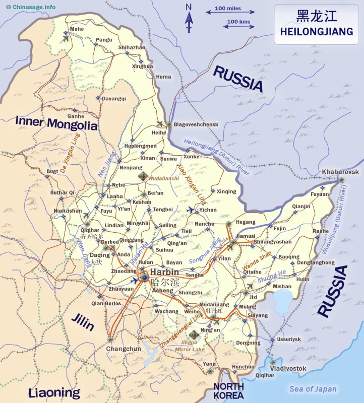
What’s not to love about Dragon Man? He was found in Heilongjiang province, not too far from the Liao River, home of the “pig dragon” artifacts and visited by Enmer and friends in The Long Guest.
Also, he is suspiciously large. At least, his skull is. Giants interbreeding with humans, anyone?
Finally, because he is a “mosaic” (a specimen that combines characteristics from what are supposed to be different branches of the human family tree), he, once again, throws a wrench into the scheme of “hominin” families as evolutionary biologists have been attempting to lay it out. As does almost every find, all the time. D.M. has even caused some scientists to question whether we should be classifying all the different “hominins” as different species at all. Q.E.D.
Near Bayou Macon, Louisiana, is an archaeological site called Poverty Point. I am drawing for information about Poverty Point primarily on the book Mysteries of the Ancient Americas, 1986, by the The Reader’s Digest Association Inc., but here is the official Poverty Point web site. It is now a World Heritage Site. Here is a recent article about an archaeological project done at Poverty Point.
First, the Obligatory Eye-Rolling at Mainstream Archaeology
Like many North American sites, Poverty Point was hard to spot because it consists of earthworks that had been overgrown with forest. (And not only North American sites. Radar technology is revealing that the Mayan civilization was much more extensive than first thought — because the jungle took over so quickly — and is also revealing old settlements in what was hitherto thought to be never-before-settled Amazon rainforest.)
Earthworks are basically impossible to date, but for other reasons, Poverty Point is thought to be about 3,000 years old (i.e. about 1,000 B.C.). However, it helps to remember that when dealing with paleontology and even archaeology, dates are often basically just made up — i.e. reached through dead reckoning based on a shaky framework of background assumptions. But let’s accept 1,000 B.C. for now.
Mysteries, which again, was published in 1986, also makes several more or less dubious claims about the builders of Poverty Point. Here’s a sampling:
“[S]cholars think it is doubtful that societies on the chiefdom level existed in North America 3,000 years ago.” (page 111)
“[This civilization] had no writing, no true agriculture, and no architecture except for its earthworks. Its weapons were simple: the spear, the atlatl, the dart, the knife, and possibly the bola. Even the bow and arrow was unknown to these people.” (page 112)
“Considering the massiveness of Poverty Point’s ridges and mounds, one naturally assumes that they were built over many generations or even centuries.” (page 112)
Mysteries of the Ancient Americas
The first of these quotes is 100% pure assumption, based on the noble savage mythology so beloved of modern academics.
The second is also pure assumption. A better way to put it would be that we have found no evidence of writing, agriculture, etc., so far. The findings reported at the first link above seem to confirm that agriculture was not a big thing at Poverty Point, based on the remains of the peoples’ diet, but this could have been simply because the fishing and foraging was so abundant. It does not necessarily mean they were “only hunter-gatherers” who had not “advanced” to the level of agriculture. C.f. similar claims being made about Gobekli Tepe. As for the bow and arrow, I take it that remnants of all these other weapons have been found, but not bows. Even that, I take with a grain of salt, as it seems that almost every week, something is discovered that we had thought this or that ancient group didn’t have. (Here’s the latest example, which even refers to ancient humans as not particularly ‘smart,’ with ‘smart’ in scare quotes.) But even if the Poverty Point people did not use bows and arrows, this does not necessarily mean the weapon was “unknown” to them. Perhaps they had specialized in other weapons instead. Not everybody in the Middle Ages was an English longbowman, but boy oh boy did they know about them!
Finally, the third claim made in the Mysteries quote box (which they at least had the grace to call an assumption), appears to have been possibly disproven by the second link above. “New radiocarbon dating, microscopic analysis of soil, and magnetic measurements of soils at Ridge West 3 found no evidence of weathering between layers of soil, suggesting that the earthwork had been built rapidly.”
Now, the Site Itself
from Mysteries of the Ancient Americas, p. 111
It’s easier to just show you guys this diagram than to try to describe it, but buckle up, here comes the description. The Poverty Point site consists of earthen ridges set concentrically inside each other, in what looks like a C-shape from the air. “The two central aisles point toward the setting sun at solstice” (ibid). Directly to the west of all this is a large man-made mound (Mound A), while a ways farther north there is a smaller mound (Mound B), which seems to be a burial mound. Bayou Macon, directly to the east, cuts through the eastern side of this whole complex. Was this whole thing originally C-shaped, or was it a circle? Probably a C shape, because there are similar, smaller sites around this region which tend to be “constructed in a semicircle or semioval pattern with the open side facing the water and with one or more mounds located nearby.” (ibid)
The book uses the word “ceremonial” a lot, and honestly I can’t fault them. This complex was constructed by human beings, and now, millennia (?) later, more human beings come and look at it and say, “This looks like it was clearly designed for ceremonial purposes.” That’s a valid argument. The architecture is having a certain effect on us, and we can assume that it had that same effect on our long-lost fellows, and was designed to.
Poverty-Point-related sites have yielded thousands of little decorated clay balls, called Poverty Point objects, that we think were used for cooking. There are also little clay sculptures of female torsos (with or without heads), reminiscent of theVenusesfound around ancient Europe. There are also “myriads of stone tools,” including drills, awls, and needles, made both from local stone and from flint imported from as far away as Indiana. They made “plummets,” perhaps as bola weights or perhaps as weights for fishnets, “most often of hematite in graceful teardrop or oval shapes [and] often decorated with beautifully executed stylized designs representing serpents, owls, and human figures.” (ibid, p. 115)
But it is in lapidary work that the Poverty Point people excelled. Pendants, buttons, beads, and small tablets are worked in an array of such colored or translucent stones as red jasper, amethyst, feldspar, red and green talc, galena, quartz, and limonite. Most of these stones were obtained by far-flung trade. Among the pendants are a number of bird effigies — red jasper owls and parakeets, and bird heads worked in polished jasper and brown and black stones. There are also representations of a human face, a turtle, claws, and rattles, and stubby but carefully made tubular pipes.
Mysteries of the Ancient Americas, p. 115
O.K., I’ve changed my mind. Perhaps this C-shaped complex was not ceremonial, it was a lapidary factory.
Regardless, the Poverty Point “hunter-gatherers” have once again made my point for me: that wherever human beings go, they start up civilization and display mathematics, art, and craftsmanship.
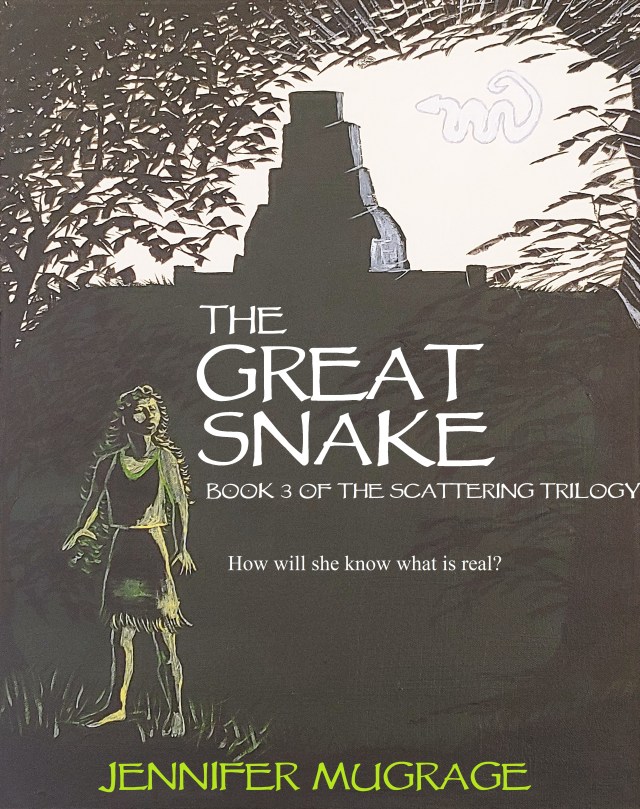
The Snake City
I guess there have been a lot of “snake cities” throughout history. In my third novel, The Great Snake (upcoming, hopefully in 2022), Snake City is founded by a small group who break off from our main group of characters. Their city is like a smaller, less populous version of Poverty Point.
As you can see, our city is much smaller. It overlooks the Mississippi River itself, rather than a bayou. The temple is built not on a man-made mound, but on a natural hill. The people actually live on top of the ridges. They aren’t lapidary craftspeople (at least, not as of the end of the novel). And, finally, this city is about 7,000 years earlier in time than Poverty Point. Other than that, though, it’s exactly the same.
In the cover image, Klee is standing on the lower hill that houses the women’s complex. Behind her, the temple looms over her from atop the hill. It has a Mayan-style roof comb that is facing away from the viewer. In this view, the snake is either hovering in the air just east of the temple, or possibly it is out over the river.
How do I love thee, cattails? Let me count the ways.
I didn’t actually love thee, not at first.
I was just writing this story, see, and in it there’s a young Native woman living all by herself near a stream. And she has a guest come to visit, and I know she’s eating game, but I wondered what she could serve him for a vegetable. Had a vague memory that maybe you could eat cattails. Put down “cattail roots” with an asterixis that let me know I needed to look it up later.
And when I did … boy howdy! My young lady had just hit the jackpot!
According to this article, cattails can provide nearly everything that a human being might need.
First of all, yes, you can eat them.
In spring and summer the young shoots can be picked, stripped of the outer leaves and eaten cooked or as a raw vegetable. The green immature flower stalks can be boiled and eaten like corn on the cob. Later in the summer months, pollen from the brown mature flowering stalks provide a nutritious flour supplement for cakes and flat breads. During fall and winter when there is no longer any foliage the roots may be boiled down for a starchy broth rich in carbohydrates. Cattail is very low in Saturated Fat. It is a good source of Iron and Phosphorus, and a great source of Fiber, Vitamin K, B6, Calcium, Magnesium, Potassium and Manganese.
“Cattail,” by Henry Holly in the The Northwest Forager, ibid
Secondly, first aid. “Ash from the burned leaves [is an] antiseptic,” and the roots and sap have also been used in first aid. Now, my character did not need any first aid, at least not at that point in the story.
Thirdly, shelter. The leaves can be woven to make such things as hats, rain cloaks, baskets, mats, and for rain runoff on a roof. (This is similar to how coconut-palm fronds are used in Southeast Asia.) And – get this! – the “seed fluff” can be used for pillows, bedding, insulation inside moccasins, wound dressing, and even … diapers. Wow! My girl’s little shelter just turned into a palace with a water-shedding roof and a comfortable bed made of a cattail mat over cattail fluff. Bonanza!
Of course, having learned all this stuff, I had to try it. As you know,I’m a Luddite, although most of the time just a pretend one.
We have plenty of cattails here in Idaho. Here is some proof, with cattails growing along an irrigation canal and the mountains in the background:
According to this article, the cattail roots can absorb pollutants in the water. Also, digging up the roots, drying and roasting them, and pounding them into flour sounded like a lot of work for someone who’s only a Luddite part-time. Actually, even digging up the shoots sounds like it would involve getting my feet wet. All in all, the simplest project for a beginning cattail forager sounds like it would be using the seed fluff. Even I can find the seed heads. Here they are:
I cut a few off with my garden clippers, and soon had a small basket full.
That ought to be enough for at least one diaper, right?
Then it was time to pull apart the seed heads. This is easy, though messy.
Luckily, the seed fluff didn’t cause any itchy symptoms. (I guess it wouldn’t be so useful if it did.) In the end, those dozen or so seed heads gave me a pile of fluff that looked like this:
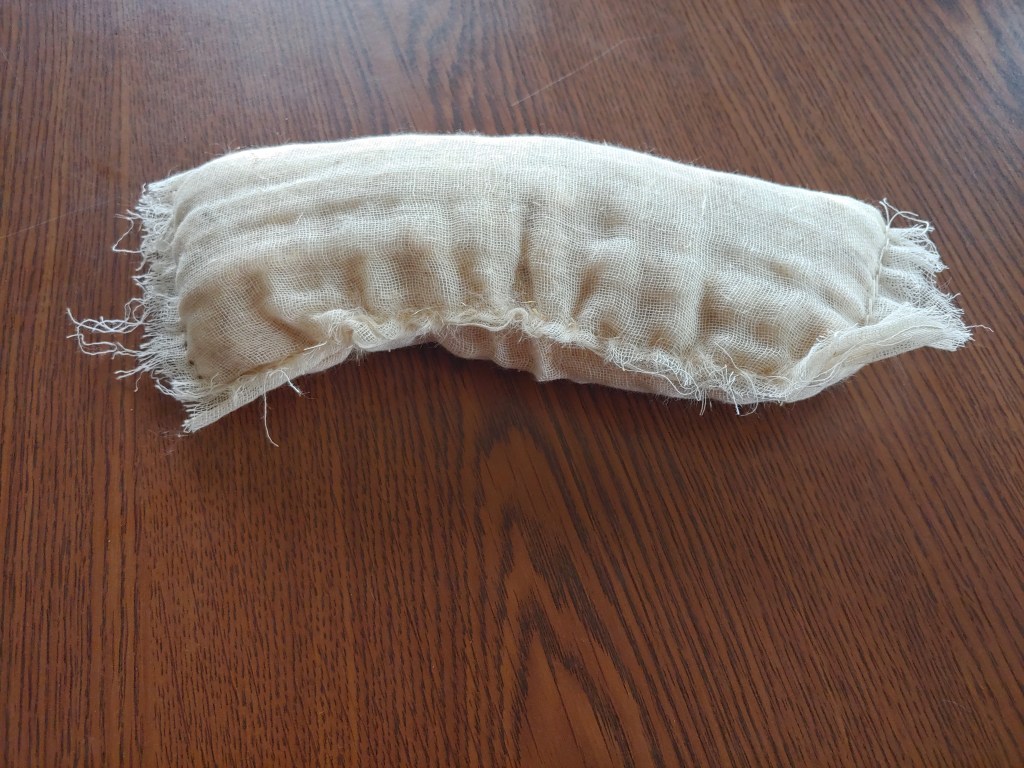
It was very fluffy and I worried that it would compact so much that it wouldn’t really be useful for bedding. But, as it turns out, it does not compact infinitely (just more than polyester stuffing from the craft store). Here’s a sample “diaper” that I made by sewing a little fluff into cheesecloth:
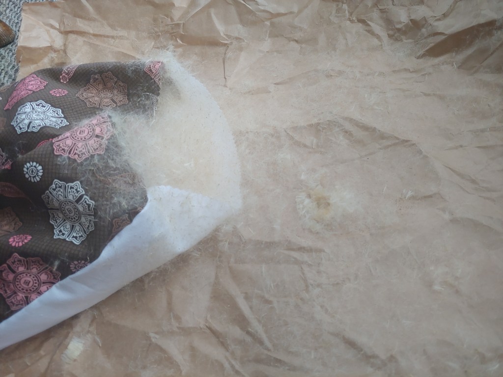
The sewing part only took me about 20 minutes. It would have taken less if I had ironed the cheesecloth first. I still had enough fluff left that I decided to make a small pillow. Out came the scrap cotton, and when the pillow was done, I stuffed it.
The seed fluff really tends to fly up in the air and then stick to stuff (that’s what it’s designed to do, after all). The pillow, once stuffed and pinned shut, ended up looking like this:
I used a lot of tape to get all the cattail lint off it.
And here is the finished product. Not super high, but a definite pillow. We’ll see how long the fluff lasts or whether it compacts a lot over time. Luckily, there is more where that came from!
This has been “researching books and pretending to be a forager” with Jen.
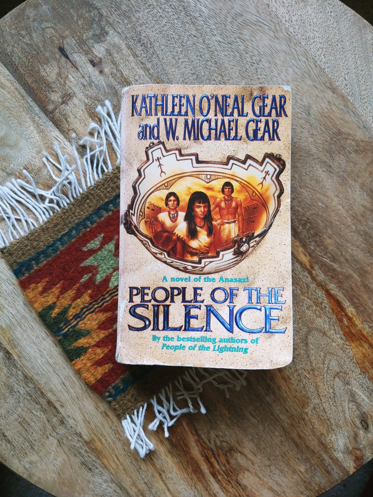
Husband-and-wife team W. Michael Gear and Kathleen O’Neal Gear write thoroughly researched novels about the different people groups living in North America in pre-Columbian times. This one, about the Anasazi or Pueblo Indian ancestors, is actually set in about 1150 A.D. This culture is “prehistoric” only in the sense that we don’t have a formal, written record of everything that went down, although there is plenty of archaeological evidence and oral tradition.
A Ceremonial City
This book comes with three maps. (I love me some maps!) The first shows North America with the general locations of the people groups who will come into play in the novel: “The Tower Builders,” “The Straight Path People,” the Mogollon, and the Hohokam. A second shows the Four Corners region, including Mesa Verde and Chaco Canyon, New Mexico, where most of the action in this book takes place, including the Great South Road built by the Anasazi and the Straight Path People’s names for all the surrounding features. I flipped back to this map many times throughout the course of the book. A third map shows a closeup of Chaco Canyon, or as the characters call it, Straight Path Wash. It shows the locations of the towns there. These can still be seen today, but the authors have given them names that the ancient Pueblo Indians might have used, such as Talon Town, Starburst Town, etc.
Talon Town (the book’s name for what is now called Pueblo Bonito in Chaco Canyon) is the capital of the Straight Path people’s civilization. It is occupied by their priest/king, the Blessed Sun; his wife, the nation’s Matron; a seer, the Sunwatcher; the nation’s War Chief; a number of warriors; and numerous slaves, mostly people captured from neighboring groups such as the Hohokam, who are there to serve these aristocrats. Talon Town produces almost no goods of its own. Food, clothing, blankets, shells, turquoise, etc. are brought in as tribute from surrounding villages over quite a wide area, or are obtained through trade. This is what the archaeological record seems to show us.
Talon Town has two large plazas, each with a kiva in it, so that it can host religious gatherings such as solstice ceremonies and funerals for important people. Here is the authors’ description of what it might have looked like inside one of the Great Kivas as a young apprentice prepares the Blessed Sun’s body for burial:
Thlatsina [=kachina] masks hung over the small wall crypts, glittering with precious stones. Thirty-six in all, they wore brilliantly colored headdresses of blue, yellow, red, and deep black feathers. Tufts of pure white eagle down crowned many masks. Neck ruffs of buffalo, badger, rabbit, and other hides gave the appearance of beards. But Poor Singer’s eyes lingered on the sharp fangs and polished beaks that glinted in the fire’s amber glow.
The circular kiva stretched at least a hundred hands across, supported by four red masonry pillars and encircled by three bench levels. Each bench had its own sacred color, yellow, red, and blue topped by white walls.
Another body rested on the opposite foot drum, covered completely by a beautiful Death Blanket. Poor Singer couldn’t guess who it might be.
People of the Silence, p. 416
Now, the Plot
Here is the review of People of the Silence I posted on Goodreads a month ago.
Some historical novels or speculative novels set in ancient times seem to cut-and-paste modern concerns onto those supposedly ancient characters. The Gears definitely don’t do that. That is one of my top concerns in historical fiction, so props to them.
It did take me a looong time to finish this. The novel starts with a steep climb through a lot of info dumps about Anasazi cosmology, including an extended vision that happens to a young man whom we haven’t gotten to know yet. All during the vision, I kept trying to figure out what the different elements in the vision represented in the cosmological scheme that had just been presented. Later, it turned out that we weren’t supposed to totally understand the vision at the time, and it would be revealed later. Perhaps, if I had read any other books by the Gears, I would have realized this sooner, but as this was my first one, I didn’t at first have that confidence.
The steep climb continues, as we are introduced to a large cast of characters. For about the first half of the novel, it wasn’t clear to me which characters, if any, I was supposed to sympathize with. In the book, the Anasazi have a brutal caste system based on “First People” and “Made People,” and slaves captured in raids on other tribes. Some of the First People later turn out to be sympathetic characters, but you don’t find that out until about halfway through the novel. Also, some characters who are supposed to be sympathetic are seen committing atrocities when we first meet them. Eventually it becomes clear that this is a very brutal society, and the prevalence and unavoidability of violence is part of the point of the novel; but again, the violence does make it hard to figure out who we are meant be to rooting for.
After the steep climb, which lasts about half the novel, we have a long plateau (a mesa top, if you will) where we are getting to know the characters and the intricate machinations taking place in their dying society. Wheels within wheels! The whole novel also includes a lot of beautiful, lyrical descriptions of the Four Corners landscape. The Gears do a great job giving you a sense of what time of day it is, what the weather and background look like, and details of what people are eating and wearing, and how they are wearing their hair. Almost every dialogue tag comes with a one-sentence description of what the character looks like at the moment (e.g. “Her greying black hair had come loose around her beautiful triangular face, which was covered in smears of reddish dust”). Stephen King would hate this, but I don’t mind it. It helps you keep track of the different characters by forming mental images of them, and it gives that much-coveted visual glimpse into what the Anasazi looked like. (For example, they dressed in bright colors, and their royalty decorated themselves with copper bells and macaw feathers.)
Finally, having scaled and then trekked across the mesa, once you are comfortable in the world and familiar with all the power dynamics, the last hundred or so pages take you on a mad, roller-coaster rush down the other side, as secrets are revealed, violence explodes, and desperate, last-minute measures are tried. This book even turned out to be a rather creepy murder mystery, with an unexpected but satisfying reveal of the murderer.
After the novel, there is an extensive bibliography of all the archaeological and anthropological sources the Gears consulted.
If you liked my book The Long Guest, you will probably like People of the Silence, and vice versa.
First of all, the tongue twister. Shaman’s snake stick. Say that five times fast! The stick was a carved wooden snake, found in a lake (stop me before I rhyme again!) or swamp, so … possibly released there on purpose?
Secondly, an adorable picture of Finns digging in the mud. They look so happy. (As anyone should when they get to dig in the mud and find archaeological artifacts.)
Thirdly, this quote: “[S]nakes are loaded with symbolic meaning in both Finno-Ugric and Sámi cosmology, and shamans were believed to be able to transform into snakes.” Add these remote people, living at the far northern edge of the world, to the long long list of the world’s peoples who find spiritual and/or cosmological significance in snakes.
This link even has a book tie-in for me! Yes, it does! The upcoming third book in my trilogy will be called The Great Snake. And yes, ithas snake cosmology. And no, this is not very original, but it is based in research. TGS is not available for pre-order yet, but you can get ready for it by buying and reading The Strange Land if you haven’t already done so. TSL is where the serpent makes its debut, at least in my books.


